Visit the EarthView web site to meet the team and learn about the project.

Thursday, July 28, 2011

Teachers of Teachers

EarthView Team: Dr. Vernon Domingo, Natalie "EarthView Wrangler" Regan,
 Rosalie "Globe Lady" Sokol, Dr. James Hayes-Bohanan
The photograph taken above is from the farewell dinner marking the end of EarthView's third year and the graduation of Natalie Regan, who served as EarthView's "Wrangler" from the program's inception. Most school visits over the past three years -- reaching close to 30,000 students in small groups -- have involved all four members of the team, and the rest of the team will miss the student worker whose dedication, creativity, and strong sense of organization has made everything possible. Upon graduation, she is pursuing opportunities to apply her geography education, mainly in the areas of regional planning and transportation.

The rest of the team brings the better part of a century of teaching experience to the program, and all of us are involved in various ways in the teaching and development of geography teachers. The "Globe Lady" Rosalie Sokol began her career as a middle-school French teacher, and switched to geography after completing an intensive training program sponsored by National Geographic in the 1980s. She retired from full-time teaching in Tantasqua Regional Middle School just as the EarthView program was getting started, and so continues to connect with students of all ages.

Dr. Vernon Domingo previously taught geography at the high school level in his home country of South Africa before coming to the United States for graduate school. He has taught in the Department of Geography at Bridgewater State University (formerly College) for 24 years. About a decade ago, he began teaching a course for future teachers, entitled Geography Methods and Materials, in which he draws on his extensive knowledge of the many tools -- conventional and digital -- available for the teaching of geography.

James "Dr. Java" Hayes-Bohanan began teaching geography as a graduate student in 1986, and became a full-time faculty member at BSU in 1997. When the department modified its program for future educators in 2005, he began teaching a course entitled "Geography Frameworks," based on the national benchmarks that have been established for geography educators at various grade levels. Students completing this course learn to apply those standards to a wide

BSU students majoring in elementary education, special education, or early childhood education must also complete a major in the liberal arts, and those who do so in geography complete both of these courses. They are also available to students pursuing the minor in secondary education, but those students are prohibited from majoring in geography, so very few of them complete these courses.

In addition to the students we reach directly through EarthView programs and university courses, members of the EarthView team are actively involved in workshops and institutes for in-service teachers -- both those already trained in geography and those who are teaching geography content but do not have geography licensure.

Update: The team gathered again in September, at the joyous occasion of Natalie's wedding. Her charming groom joined the team just for the photo op!

Wednesday, July 6, 2011

Kermadec Quake

29.312°S, 176.204°W
(Note decimal degrees; see lat/long article for information about conversion. How many degrees is this from your school?)


Orange, yellow, and green are closer to surface;
blue and violet are deeper than 150km
see map page for more details and views
Thanks to our local paper, the Brockton Enterprise, for letting us know about the magnitude 7.8 earthquake that struck the very remote Kermadec Islands earlier today (although it was already "tomorrow" where the quake occurred, just a few degrees east of the International Date Line. (The Globe and Mail provides just a few more details.)


The remote outpost of New Zealand houses only a weather station (currently 67 degrees F with a light breeze) and a hostel for visiting scientists. It is almost 1,000 kilometers south of Tonga, the nearest "major" island and almost 1,200 kilometers northeast of Auckland. The earthquake is remote even from these islands, with Raoul Island, the nearest, over 100 kilometers away. (See EarthView blog posts about another remote New Zealand island, Tokelau.)


The quake occurred 44 kilometers below the surface, which leads the USGS tentatively to conclude that is is located in a normal fault within the downward-moving Pacific plate.


The map at right is among several interesting depictions of seismic activity in this remote area. It indicates that the area is seismically quite active, with thousands of mostly small events over the past twenty years. Although the depth of each event can vary according to many factors, in subduction zones of this kind, the tendency -- well-illustrated here -- is for shallow events to cluster near the fault line, with depth increasing with distance away from the advancing plate (in this case, westward as the denser Pacific Plate advances under the Australian Plate).


As with any major quake in a marine environment, tsunamis are a possibility, and in this case it appears that a 2.2-foot wave was the highest generated by the event.

Tuesday, July 5, 2011

Pan-American Highway Tour

Geographers love transects, and we have shared several interesting examples with our EarthView audiences in the past couple years. A really quick one is taking place right now, as a three-person team is driving a single automobile along the entire 16,000-mile route of the Pan-American Highway.

Knowing that they started in Argentina and will follow a west-coast route all the way to Alaska, see if you can identify all the countries and major cities they will visit before checking the TDI-Panamericana web site to learn all the details.

This trek involves three drivers, 16,000 miles, 14 days, and a 2011 Volkswagen. EarthView team member Dr. Hayes-Bohanan did something almost as crazy in 1985, involving two drivers (both geographers), 8,500 miles, 17 days, and a 1960 Volkswagen. Our top speed was 62 miles per hour, and we visited only two countries: about half of the states in the U.S. plus Baja California. It was the start of what eventually became the County Map Project.

Thursday, June 30, 2011

Rumney Marsh Art

The EarthView team very much enjoyed our visit to the Rumney Marsh Academy in May, where we found a school full of enthusiastic geography teachers and learners. We were delighted to receive a series of wonderful posters created by RMA students, who apparently were quite inspired by the EarthView experience! We will treasure them all, and decided to share just one example here on the blog.


Click to enlarge!

Friday, June 24, 2011

Neither Niña nor Niño


The past six months or so have been punctuated by a series of extreme weather events in North America, from strong winter storms to rapid snow melt to tornadoes of unusual intensity, most recently in Massachusetts, far from their typical range.

Often such anomalies are ascribed to El Niño events -- accumulations of unusually warm water in the equatorial Pacific the prior December -- or La Niña, the opposite. According to NASA Science News, however, the 2011 events seem to result from an unusually free-wheeling jet stream, which in turn results from "La Nada" -- a lack of a strong Pacific temperature signal in either direction.

Friday, June 17, 2011

Not Just French

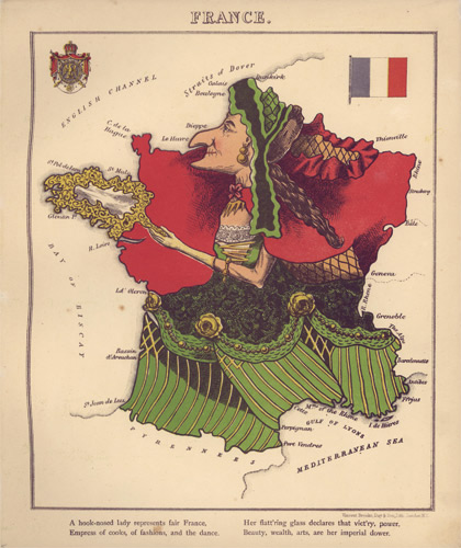
The woman on the map below is not just French ... she's France!

It is one of several maps in the form of people, plants, or animals included in Maps Come Alive on the Streets of Salem blog.

Phil Cambell

"Who is Phil Campbell?" That is a simple question with many answers, and an even better question is "Where is Phil Campbell?" The answer to that is northwest Alabama, more precisely at 34°21′N; 87°42′W.

And for the next few days, the question is "Where are the Phil Campbells?" To which the answer is "Phil Campbell." Got it?

Phil Campbell -- one of them, anyway -- was a railroad builder from England who was leading work crews in northwestern Alabama in the 1880s. A local business leader asked him to build a side track and depot, offering to name the town for him if he did so. The result is that Phil Campbell is the only town in Alabama to bear both the first and last name of an individual.

I first heard of the town of Phil Cambpell in 1995, when New York writer Phil Campbell organized a convention of 22 people named Phil Campbell in the town. Phil Campbell -- the writer and the town -- are in the news again this week.

In April of this year, the town of Phil Campbell experienced a devastating tornado as part of the 2011 Super Outbreak. At that time, the writer Phil Campbell and others were already planning another convention to take place in June. As reported on NPR Thursday, the Phil Cambells -- this time coming from all over the world -- have transformed their celebration into a relief effort.

The "I'm With Phil" project is restoring hope to a town some thought might need to be abandoned. It is amazing what these eighteen men (at least one Phyllis was planning to attend but is not in good health) are doing, united by nothing more than compassion, a sense of humor, and an unusual toponym.

Wednesday, June 15, 2011

Granite Valley Middle School in Monson -- June 17

42° 06' 35" N
72° 19' 11" W

Learn more about Lat/Long


The EarthView team will mark the end of our third year -- and the departure of our graduating EarthView Wrangler -- at Granite Valley Middle School in the town of Monson. This will be our westernmost appearance this year, though we were only a few arc-minutes east of Monson when we visited Sturbridge at the beginning of this week.


As many people in our region now know, it was just two weeks ago that the town of Monson was among the  communities that suffered the most devastating property damage during the June 1 outbreak of tornadoes in western and central Massachusetts. Tragically, several lives were lost in the Springfield area, but good forecasting, communication, and cooperation prevented the human impact from being much greater. 

Click to Enlarge
View original and commentary at EarthSky
The impact of losing so many homes and public buildings, however, is quite serious. The Monson Public Schools have been an integral part of the effort to bring the community together around the recovery effort


Tornadoes occur rarely in Massachusetts, so when we were teaching EarthView audiences about the geography of tornadoes in April, we had no idea the subject would soon be so close to home. As reported on the EarthSky blog, NASA Landsat images reveal the scope of the damage, as a single path of heavy damage extends for a length of 39 miles, with a width up to a half mile.


For centuries, the physical geography of Monson has influenced its history. Located in a region of abundant rainfall and high topographic relief (range of elevation), Monson was an ideal location for industry during the age of water power. As early as the late 1600s, mills in Monson produced a variety of products, ranging from lumber and woolens to hats and rifle barrels. Below the surface, local granite has been sufficient for the construction of many public buildings in town, with enough leftover for use throughout the Northeast.

Monday, June 13, 2011

Tantasqua Regional Jr. H.S. -- June 13

42° 09' 24" N
72° 07' 44" W

Learn more about Lat/Long


The EarthView team is delighted to be visiting Tantasqua Regional Junior High School in historic Sturbridge. As students there know, this is the school where the famous Globe Lady worked as a geography teacher before retiring and joining our team! EarthView has been to Tantasqua only once before, in 2008.


Thursday, June 9, 2011

Weymouth -- June 3

Abigail Adams Middle School
42° 13' 21" N
70° 56' 21" W
Academy Avenue Primary School
42° 13' 15" N
70° 56' 33" W

Learn more about Lat/Long


The EarthView team enjoyed a day in Weymouth -- a town located about halfway between our home base and Boston. We set up EarthView at Abigail Adams Middle School, to provide programs to students from the Academy Avenue Primary School, who walked a few hundred yards to participate. The coordinates posted above -- based on the official address of each school -- can be used to determine the arc length the students covered.


We were delighted to have as special guests for the day Rep. James M. Murphy, who represents Weymouth in the Massachusetts Legislature, and his staff members, including an intern recently arrived from Ireland! Rep. Murphy and his staff exuded great enthusiasm for geography education. More importantly, so too did the students, teachers, and staff of the two schools. The enthusiasm for EarthView and geography was high throughout the day, and the students showed that they had been learning their geography concepts quite well!


We look forward to returning to Abigail Adams to do some more geography education with students, teachers, and Principle Dan Birolini, a former geography teacher who once took a course on the Geography of Africa with EarthView' team member Dr. Domingo!


Wednesday, May 25, 2011

Salem to Mongolia


During our recent visit to the Rumney Marsh Academy in Revere, the EarthView team was pleased to meet science teacher Andrea Aeschlimann, who is about to embark on a remarkable humanitarian -- and geographic -- project. In the Salem to Mongolia project, she and a partner will deliver a wheelchair van to a community in Ulaanbataar, Mongolia.  As the map above suggests, the van will be sent by ship to London, and then driven the rest of the way, forming a transect of most of Eurasia. The trip is a chance to do some good and to learn a lot of geography on the way!

Tuesday, May 24, 2011

Quabbin Middle School

42° 24' 07" N
72° 06' 47" W
Learn more about Lat/Long

For the third year in a row, EarthView will be at the Quabbin Regional School in Barre, where geography teacher Erin Stevens organizes an annual sleep-over for seventh graders. During the first four hours of the event, participants take turns visiting EarthView, among other fun programs throughout the building.

The regional school is named for the Quabbin Reservoir, which famously eliminated four towns in order to provide water to Boston.

Wednesday, May 18, 2011

Rumney Marsh Academy, Revere: May 20

42º 24' 47" N
71º 00' 12" W

Learn more about Lat/Long


The Rumney Marsh Academy is located in Revere, a city of just under 6 square miles and just over 42,000 residents located on Cape Cod Bay just a few miles to the north of Boston's Logan Airport. The historic city of Revere is the birthplace of noted American author Horatio Alger


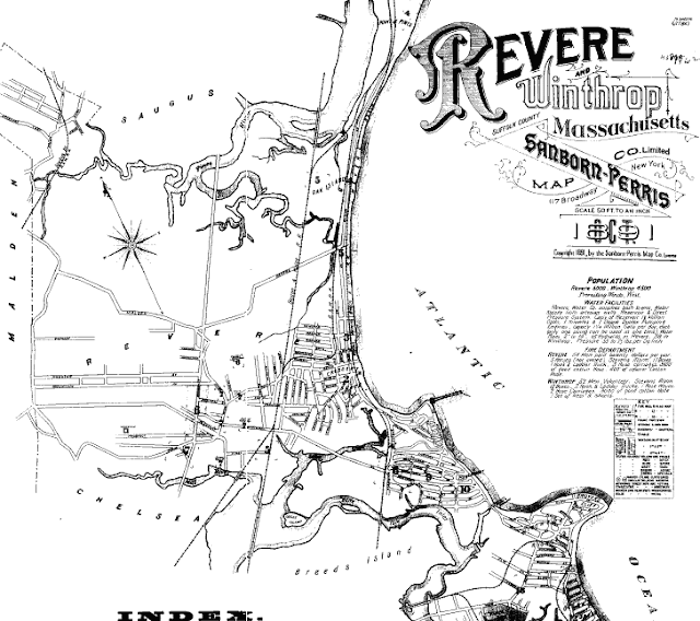
The Rumney Marsh Academy is located on American Legion Parkway, less than a mile from the important wetland for which it is named. The Rumney Marsh is the largest wetland area on the north side of Boston. Coastal environments can change quite rapidly, especially where human settlements are close to the coastal environment. In the case of the Rumney Marsh, however, its general shape is roughly the same as it was over a century ago, according to the 1891 map shown below.


According to the Rumney Marsh Information Page hosted by the U.S. Environmental Protection Agency, glaciers were involved in the formation of Rumney Marsh in three ways. First, a glacier deposited the sand that forms Revere Beach, separating the Marsh from the Atlantic Ocean and diverting the lower stretch of the Saugus River a bit northward. Second, outwash from melting glaciers carried much of the silt that forms the marsh. Finally, when glaciers retreated throughout the Northern Hemisphere about 10,000 years ago, sea levels rose throughout the world, in this case raising the ocean to just the right level for sediments in the Saugus River to be trapped in Rumney Marsh.


Learn more about the Rumney Marsh and its ecological importance from the Rumney Marsh Reservation page and from the page that identifies the marsh as an Area of Critical Environmental Concern (ACEC). The Rumney Marsh is a good place to see the influence (no pun intended) of tides.


Source: 1891 Sanborn Map

Where is the Center?

One of our BSU geography students recently shared a story about the placement of a monument in Missouri that marks the population centroid of the United States. The story is told on EarthView team member Dr. Hayes-Bohanan's Environmental Geography blog, in an article called Plato at the Center.

Sunday, May 15, 2011

Tide's Up!

Blondie's 1980 hit The Tide is High may no longer be as popular as it once was, but the EarthView team was still surprised to learn that many university students are not aware of what real tides are.

Cape Cod Low Tide
Tides are regular fluctuations in the water level of oceans that result from the gravitational pull of the sun and the moon. Water levels typically rise and fall twice each day, with the difference between high and low tide ranging from a half meter in some locations to as many at 15 meters in the extreme case of the Bay of Fundy. Typical ranges are on the order of a meter or two. Learn all about tides from the Tides and Water Levels page at NOAA's Ocean Service. See NOAA's ocean education page for many more tutorials, games, and lesson plans about the oceans.

High and low tides do not arrive at the same time each day, nor do they arrive at all coastal locations at the same time. Even places that are very close together can experience tides at very different times because of the shape of the coastal environment. The timing of tides is very predictable, though, so newspapers in coastal areas usually publish expected high and low tides for several days at a time. The web site Salt Water Tides allows internet users to look up tidal charts for many U.S. locations up to one year in advance. These charts are reliable for the timing of tides, but the magnitude of high and low tides can be affected by many other factors at a local or regional scale.

Saturday, May 14, 2011

Return to Wakefield -- May 13

Woodville School (where we are presenting EarthView)
42º 29' 53" N
71º 03' 04" W


Walton School (which sent second-grade classes on a but to see EarthView at Woodville)

42º 30' 23" N
71º 05' 15" W


Wakefield High School (which is sending an oceanography/astronomy field trip to EarthView)

42º 29' 46" N
71º 03' 07" W

Learn more about Lat/Long

Note: two the schools are at adjacent addresses on Farm Street in Wakefield. The are only a few arc-seconds apart, in both latitude and longitude. Compare this distance to the distance from Farm Street to the Walton School on Davidson Road.


View Larger Map

The EarthView team enjoyed giving first- and second-grade students from the Woodville and Walton Schools an unforgettable view of the earth! We were also able to building on the lessons Wakefield High School students have been learning about latitude and longitude (see link above), plate tectonics, and the formation of the earth. We also learned about GPS by having several high school students pretend to be satellites and a ground receiver.

All of the Wakefield schools we visited this year are doing a great job with geography -- students at all grade levels showed great interest in their world! The Walton School home page features the nifty geographic clip art shown at right!

Thursday, May 5, 2011

Upcoming EarthView Visits

The following is a partial list of EarthView programs taking place in coming months (revised May 5, 2011). All town and city names are in Massachusetts, unless otherwise indicated. We are currently accepting requests for 2011-2012 reservations.  Please see the EarthView web site for requirements and contact information.

For both pedagogic and security reasons, participation at school programs is limited to the students themselves, unless prior arrangements are made for visitors. Certain EarthView events are open to the public, as indicated below.

Friday, May 6
St. Joseph Elementary, Needham

Friday, May 13

TBA Elementary, Wakefield

Friday, May 20

Thomas Carroll School, Peabody

Thursday, May 26

Quabbin Regional Middle School  (overnight)

Friday, June 3

Abigail Adams Middle, Weymouth

Friday, June 10

TBA North Shore

Thursday, June 16

Granite Valley Middle School, Monson

Friday, June 17

Tantasqua Jr. High School, Fiskdale

Wednesday, September 7 
PUBLIC EVENT
Worcester State University
Theme Semester Kick-Off: Worcester in the World

Thursday & Friday, October 6 & 7

North Andover Middle School
EarthView programs by day; Geography night in between!

Wednesday, May 4, 2011

St. Joseph Elementary, Needham: May 6

42º 16' 58" N
71º 14' 04" W

Learn more about Lat/Long


EarthView will be at St. Joseph Elementary School in Needham on May 6, and is delighted to have been mentioned in the "Looking Ahead" section of the Principal's Corner online!


The EarthView team was in Needham just about a year ago, at the Eliot School. Students can use the lat/long article above and our Eliot School blog post to determine the angular distances between the two schools. For example, which school is farther north, and by how many degrees, minutes, and seconds?


www.northshoremaimages.com
The history of Needham includes some interesting geography. As with many areas at a similar distance outside of Boston, its economy during early English settlement was almost entirely in agriculture, giving way first to tanning and lumbering. Imagine forestry as a significant industry 250 years ago, with cattle grazing over much of the unforested area, and those cattle supplying a noxious industry involved in the tanning of leather for shoe factories elsewhere in the region. A century later -- by the 1850s -- a knitting industry had emerged, owing in part to the migration of expert knitters from England. We say "in part," because it certainly appeared to those involved that the industry persisted in Needham just because certain skilled workers had come to the area. For geographers, though, this is not a final answer, but rather the beginning of questions: why did expert knitters move here, rather than some other location? Individual choice is often important, but so, too, are factors such as climate, available sources of energy, and available raw materials.


Moving forward another century, the economic geography of Needham was part of a dynamic area that many geographers have studied. The 128 Corridor, as it came to be known, far enough from Boston to have relatively less expensive land for the building of office parks (some of the nation's first) and small factories. It is close enough to Boston and Cambridge, however, to draw on the intellectual and technical expertise available at a variety of institutions, particularly the Massachusetts Institute of Technology and Harvard.


Team member Dr. Hayes-Bohanan makes the journey from Bridgewater to Needham about once each month, to visit Trader Joe's, which is an interesting grocery store for a geographer to visit. In addition to a vaguely Polynesian decor, the store offers many lessons in the geography of food, as people come to the store seeking particular combinations of local, exotic, and healthy foods. It also includes a small but diverse section customers can explore the geography of coffee and tea


The store is also a very interesting example of economic geography. Not only does it manage to attract shoppers from a much wider range than most grocery stores, but the store's management also takes a very different approach to the economic geography of the inside of the store. In grocery stores, products compete for shelf space. Certain areas have higher value than others, based on proximity to the checkout lines, height relative to eye level (adult and child might be different), and other factors. All of this is true in Trader Joe's, but  the space is managed very differently. In a big store with a lot of shelves, it makes sense for some products to be offered in many sizes and varieties, just to take up space. Most stores let suppliers do this, so that a single category -- such as soft drinks, chips, or cereal -- can take up an entire aisle. Trader Joe's does something quite different: the shelving is limited, so its value (the "rent") is high, and each kind of product will be offered in relatively few varieties (compared to big stores, anyway) and very few sizes (usually only one).


Activity: When you visit grocery stores or other retail establishments, pay attention to the arrangement of products on shelves and racks. How can you tell which areas of the store have the highest value? The lowest? How do organizing strategies vary among stores?


Monday, May 2, 2011

Royal Wedding Geography

Photo: HappyLand Royal Wedding Set
Our most recent EarthView program coincided with rather a fancy wedding ceremony in London, as Prince William married his long-time girlfriend Catherine (Kate) Middleton. Not since William's parents married in 1981 has there been so much attention to a wedding ceremony. The significance of the event goes far beyond its importance for the happy couple, of course. The latest royal wedding is full of geographic implications and raises many interesting questions students can explore, starting with: Why is the couple now known as the Duke and Duchess of Cambridge?

Two other geography blogs have described a number of geography lessons to be explored. "Millie the Geographer," writing on her What I Taught in Geography This Week blog, begins with several examples related to the geography of tourism. (Yes, tourism has a geography, and the Association of American Geographers even has a specialty group for its study!) The blog post goes on to include implications for retail sales and the importance of social media, which are also a growing area of geographic inquiry. Related to political geography, the blog discusses the relevance of the wedding to public opinion regarding the monarchy. Finally, the availability of "copycat" royal weddings in China is cited as an example of the cultural geography of Westernization.

In The Geography of the Royal Wedding, the Living Geography blog mentions some of the same themes, including the specific example of  retail impacts shown above. This blog also provides links to several geographic aspects of the wedding day itself, such as maps of the procession and weather at the time of the ceremony. It also includes a link to an interesting series of cartograms about the UK, which in turn helps to explain some of the often-confusing terminology related to the name of the country in which all of this is taking place.

The list of invited and attending guests has also been quite interesting. One gallery of royal wedding guests lists just a few of the "in" and "out" celebrities and dignitaries -- most notably President and First Lady Obama -- and provides some interesting details about their status. Several instructive geography activities could be built around a longer -- though still selective -- list of attendees from the wedding's official web site.

Using the various categories of guests in this list, consider the following options:

1. Using a detailed map of the United Kingdom, map as many of the "Members of the Royal Family" in attendance as possible. What parts of the UK are most represented? Least?

2. Using a map of the world, map the attendees who are members of monarchies outside of the UK. What current monarchies are missing?

3. The "Dignitaries" includes officials from other countries. How many of these are members of the Commonwealth (of current and former British colonies and territories)?

4. What religious sects and denominations are represented by the clergy and other religious leaders present? In what parts of the world are adherents of these religions found?

Friday, April 29, 2011

Tornadoes

Tragically, tornadoes are very much in the news this week. We will have more about this topic on the EarthView blog soon, but meanwhile we want to let teachers, parents and students know about two important resources for understanding the geography of these storms.

U.S. Tornado Climatology is a report from NOAA that explains why tornadoes are more likely in certain places and at certain times of the day or year.

The Tornado History Project is a geographic database of 54,000 tornado maps, covering U.S. events from 1950 to 2010.

Thursday, April 28, 2011

W.H. Galvin Middle School, Canton -- April 29

42° 10' 05" N71° 07' 57" W

Learn more about Lat/Long

The EarthView team is pleased to be meeting with seventh graders at the William H. Galvin Middle School in Canton, where one of our own BSU Geography alumnae is part of the excellent social studies team. For some reason, we have not included W.H. Galvin in the blog previously, but we do know that Galvin students are always well prepared to show off what they know about geography!

Canton, Massachusetts is named as the result of an interesting but common geographic misconception. Originally known by the Algonquin name Punkapoag and later part of the town of Stoughton, it became a separate town in 1797. At that time Elijah Dunbar suggested that it be named for Canton, China, which he thought was on the other side of the earth. The common misconception that North Americans could "dig to China" was thus immortalized in the name of the town.

In reality, Canton, China -- now known as Guangzhou -- cannot be on the opposite side of the earth from Canton, Massachusetts, as both are in the northern hemisphere. Guangzhou is at 23°N and 113°E, so it is close to the correct longitude, but nowhere near the correct latitude to be considered the antipode.

Learn more about true antipodes from Dr. Hayes-Bohanan's antipode article on Environmental Geography. Find the true antipode of Canton -- or anyplace else -- at the Antipode Map web site.

From here ... to there?

Canton is known for many other things, including two factories built by Paul Revere (one for gun powder and another for brass and copper rolling), its famous viaduct, and Dunbar's founding of the oldest choral society in the United States, which remained in Stoughton. 

As a former location of Equal Exchange, Canton is the first of many places that EarthView team member Dr. Hayes-Bohanan had a chance to visit a coffee company!

Tuesday, April 26, 2011

Biggest Seas

One of the major lessons of EarthView is that "Earth" would more appropriately be called "Water," since more than 2/3 of the planet is covered with water -- at an average depth of about 3 kilometers! The Pacific Ocean, of course, is the largest body of water, and also the oldest, with the crust in some areas is 200 million years old. (Pretty old, but less than one-tenth the age of the planet!)

Writing for Our Amazing Planet, Remy Melina has created a countdown of the ten largest oceans and seas, with imagery and fun facts about each. Which one do you suppose is shown above? What bodies of water do you think made the top-ten cut?

Monday, April 25, 2011

New Islands Discovered!

Gurupi Islands -- Google image from CoastalCare.org
The title above is attention-grabbing and a little inaccurate ... on purpose. Read the details on Dr. Hayes-Bohanan's Environmental Geography blog.

Monday, April 11, 2011

State House Coverage

The EarthView team has had the privilege of setting up EarthView in the Massachusetts State House twice - first in June 2010 and most recently this April 4. Each time, students from the Geography Club at Quabbin Middle School in Barre have been part of the effort, asking visitors questions about their knowledge of geography.

Those visitors have included a variety of state senators and representatives and their staff members, as well as tourists who happened to be visiting the State House (a grand, historic building that attracts visitors from near and far).

Boston Globe photographer David Ryan was fascinated by the giant globe filling Nurses' Hall, and enjoyed photographing EarthView and the people in and around it. In addition to a cover photo on the next day (click at left to enlarge, but the digital version remains a bit fuzzy), two short articles appeared in the paper. John Ellement's Global Silhouette piece features two of our BSU students showing the world to legislative staff.   Saving the World for Geography by Katherine Landergine features one of our Massachusetts Geographic Alliance colleagues who ensured that the hand-painted globe did not scrape against a marble banister. Her article also mentions SB 182, which Senator Brewer's introduced to promote geography education in the Commonwealth.

Saturday, April 9, 2011

SciGirls Expo - April 9

41° 44' 30" N
70° 37' 20" W

See the Steve Morse lat/long finder to look up other addresses, or read the EarthView lat/long article for much more graticular information


The EarthView team is delighted to be part of the SciGirls Expo being held at Mass Maritime. The campus is an excellent model of innovation in sustainability, with many leading-edge projects to reduce greenhouse emissions through the use of wind, geothermal, solar, and tidal power!

The Expo is meant to cultivate another great source of power: the mind! High school girls considering STEM -- that is Science, Technology, Engineering, and Math -- careers will be learning about all kinds of career possibilities in science, including geography.

Thursday, April 7, 2011

McCall Middle School, Winchester: April 8

42° 27' 01" N
71° 08' 05" W
See the Steve Morse lat/long finder to look up other addresses, or read the EarthView lat/long article for much more graticular information!


The EarthView Team is visiting McCall Middle School in Winchester, one of several adjacent or neighboring "W" towns just north of Boston. We have already been in adjacent Woburn, for example. The Massachusetts city/town map reveals that it is possible to travel considerable distances north and west of Boston without ever leaving places that start with either "W" or "M."


Winchester's early development was fostered by the 1803 opening of the Middlesex Canal, whose path through the town seems largely to have been obscured, except in a few locations along Palmer Street. Geographers tend to be fascinated by canals, which are like rivers in some ways and railroads in others. 


Geobiblio Stunt


The Library History Buff blog recently posted what it calls the Best Library Cover Story Ever. It is a good geography story, too! It is the story of a very special letter mailed in 1952.

Sunday, April 3, 2011

State House: April 4

The EarthView team is pleased to be returning to the Massachusetts State House on April 4. The photo to the left is from our previous visit in June 2010. We met a number of enthusiastic legislators, staffers, and tourists during that visit, and we are looking forward to another great day in the People's House.

We will be in the State House from 8:30 a.m. to 2:00 p.m. Throughout the day, geography students from Bridgewater State University will be on hand, along with students from the British School of Boston, Quabbin Middle School, and teachers from the Massachusetts Geographic Alliance.

Many thanks to Senator Steve Brewer of Barre for organizing this visit, and to the other champions of geography education in the Massachusetts General Court.

Mass Geo Blog

When we are not in our own community spreading the good news of geography, members of the EarthView team enjoy visiting other parts of the global community. We know that we are very fortunate that our work and leisure have taken us to many places -- more than 50 countries among the three "senior" members of the team.

Dr. Domingo is currently adding at least two countries to that total, as he spends part of his academic sabbatical teaching and learning about water resources in Malaysia and Cambodia. As time and internet connectivity allow, he has been posting short updates on the blog of the Massachusetts Geographic Alliance, one of our Project EarthView partners.

The Mass Geo blog is not just about our travels, though: the main purpose of the blog is to provide a place for educators to share ideas about the teaching of geography in Massachusetts. We therefore invite all of the teachers and volunteers we meet through Project EarthView to follow the Mass Geo blog for news, lesson ideas, and -- yes -- the insights of traveling geographers!

Saturday, March 19, 2011

What's the Best Projection?

See National Atlas.gov
As geographers -- especially geographers who travel with a giant globe -- we are often asked this question. What kind of map, people want to know, will eliminate distortion?

Because the earth is nearly spherical in shape, a globe is the only way to represent it without distorting shape, area, distance, and/or direction. Any effort to preserve one of these four properties will require a loss in one or more of the others. Therefore, the "best" projection will vary, depending upon which of these characteristics is most important. As a guide for sailing a ship, direction is extremely important, for example. Unfortunately, the projection that best achieves this -- the Mercator -- has become one of the most popular for world maps, even though it grossly distorts area, shape, and distance!

NationalAtlas.gov is the online version
 of the official National Atlas of the US,
first printed in 1874.
The National Atlas article Map Projections: From Spherical Earth to Flat Map is the best place to start learning about the trade-offs among the various projections. Further detail is provided by the U.S. Geological Survey article Map Projections, which includes a series of tables that identifies the suitability of various projections according to the properties preserved, the scale at which each is appropriate, and the appropriate use of each. Both the National Atlas and USGS articles include helpful glossaries, and describes the trade-offs that apply to globes, as well as to flat maps.


EarthView is nearly unique (duique, as Dr. Hayes-Bohanan says, because there are two of these special globes in the world), so its advantages and disadvantages differ from ordinary globes. Compared to most ordinary globes, EarthView:

  • has a much larger scale, and therefore more detail
  • has a much larger scale, but still not nearly as detailed as a typical highway or city map
  • is hand-painted, so features are more vivid
  • is hand-painted, which introduced a few small errors (ask the team where they are!)
  • is hand-painted, so it has to be treated with extra care
  • is very tall, so much of the northern hemisphere is hard to see from outside
  • is very tall, so some things are best understood from a distance
  • is very tall, so it does not fit in most classrooms or homes
  • is not round on the bottom, so Antarctica is flattened (and is not visible from the outside)
  • has a zipper on the International Date Line, which is just cool
  • has three air holes in the top, and a fan on the side -- also cool
  • rests on the South Pole, so it does not properly show the tilt of the Earth's axis
  • can be viewed from inside, so the entire planet is visible at the same time (except whatever is right behind your head)
  • can be viewed from inside, so that east appears on the left and west on the right (north is still up, though)
  • can be viewed from inside, so it looks like stained glass (see Mapparium in Boston for a globe made of real stained glass)
  • is a physical globe -- whereas most ordinary globes are combined physical/political -- so country boundaries are not visible (except island nations, of course)
One of the most noticeable differences between EarthView and other maps and globes is that in EarthView (or outside of EarthView) we can more clearly see that the Pacific Ocean is full of islands -- many of them inhabited. For example, French Polynesia is an "overseas collectivity" of France with over 100 islands and nearly 300,000 people, and is just one of many clusters of archipelagos in the vast Pacific Ocean.

The comparative visibility of Pacific Islands is a function of both projection and scale. On many flat maps of the world, the Atlantic Ocean is centered, with the Pacific pushed to the edges. On both maps and globes, a typical Pacific Island -- if shown to scale -- is comparable in size to the dot of a letter i, and therefore very difficult to represent. Even on EarthView, some artistic license has been used to make the islands more visible. Though the islands themselves are drawn to scale, the shallow waters around them generally appear much larger than would be proportional.

Learn more about the Pacific islands from two previous posts on this blog -- A Vast Ocean and Survivor Islands. We also recommend the interactive Map South Pacific site for finding maps of specific regions and archipelagos and the CIA's Oceania map (PDF format) for an overview.