A week after that, they caught a sea bird, which would be their only food source until being rescued on November 24, about 600 miles from home. They wHere taken to a hospital in Fiji, where they were found to be in remarkably good health.
They survived long after funerals had been held for them, and were at sea longer than has been documented for any other unsupported humans.
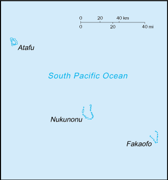
The unusual spatial pattern of the islands of the Pacific is one that many EarthView visitors find amazing. Fiji is close to the International Dateline, just off the top of EarthView's zipper. Hundreds of other islands are found throughout the Pacific -- far more than in the other oceans -- often tiny dots that are separated by huge distances, and arranged in interesting ways. Tokelau is a series of three rings, each a few miles across, with people able to inhabit only the outer edges of each. The rings are spaced evenly over 100 miles, but with a total land area of only 5 square miles! At 1,500 people, the population of the country is less than half the size of the student body at the public high school in Brockton, Massachusetts!
 |
CIA map from thePerry-Castañeda Library Map Collection |
Learn more about the fascinating geography of this region from Maps of the South Pacific, a travel web site that provides an interactive map of the region as a whole and individual maps of each country. The site also explains the distinctions among Polynesia, Micronesia, and Melanesia. (It does not cover Macronesia, which is nearly antipodean, in the North Atlantic.
Earlier this year, the EarthView team followed the progress of Katie Spotz, whose Row for Water project took her across the Atlantic Ocean. She was at sea for 70 days, in a well-stocked boat and plenty of communication equipment. From her voyage we learned some of the risks involved in small-craft travel on the high seas.
Both for Katie's planned voyage and for the boys' unplanned voyage, fresh water was, ironically, a key consideration. Katie had a water filtration kit. The boys used a tarp to gather rain and mist at night. In their case, this was starting to be inadequate and they had begun to drink seawater, a dehydrating practice that would likely have proven fatal had they been at sea a few more days.
See BBC video about the story.


No comments:
Post a Comment