
EarthView allows students to consider GPS from the point of view of the satellites. We can use small tokens to represent the satellites (not to scale) and 33-foot-long pieces of string to represent their orbital distances (to scale). This blog post is intended to provide further insight into how the systems work.
This image represents the 24 satellites used in the now-familiar system known as GPS, or Global Positioning System (public-domain image courtesy of WikiMedia). The earth is shown in the center, with a black arrow constantly pointing to a position 45 degrees north of the equator. The blue rings represent the six orbits, in each of which four satellites circle the planet twice each day.
The time scale is greatly exaggerated, with 30 seconds representing a 24-hour period. The spatial scale, however, is fairly accurate -- Earth is 8,000 miles in diameter, and the satellites orbit about 12,000 miles above the surface.
 Dashed, green lines connect the point on the ground to the satellites that would be in a direct line of site from that point. The image illustrates how the number of satellites "visible" at any one time varies from 6 to 12. As explained in more detail on the Smithsonian GPS page, a minimum of four is needed to identify a unique location.
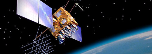
Each GPS satellite is a one-ton, 17-foot, solar-powered vehicle that carries an atomic clock and follows a precisely defined orbit. With just 50 watts of transmitting power, the satellite constantly sends out its location and the precise time. A ground instrument can use the time to determine how far it is from a particular satellite, but this information alone does not define a location, as the direction from the satellite is not known. By calculating the distances from four satellites, however, the overlapping distances define a unique point. Greater numbers of satellites allow for correction of measurement errors.
The GPS technology defines where a receiver is; this is combined with sophisticated geographic information systems (GIS) and routing technology to allow for on-the-spot calculations of pathways from one's current location to a desired destination. Many professional geographers, by the way, were reluctant to use GPS technology because of our love for tradtional, paper maps. As the technology has become more sophisticated -- and convenient -- more geographers have embraced it ... but tend to use it in combination with "real" maps as well!
 |
| Source: WikiMedia |
The time scale is greatly exaggerated, with 30 seconds representing a 24-hour period. The spatial scale, however, is fairly accurate -- Earth is 8,000 miles in diameter, and the satellites orbit about 12,000 miles above the surface.
Dashed, green lines connect the point on the ground to the satellites that would be in a direct line of site from that point. The image illustrates how the number of satellites "visible" at any one time varies from 6 to 12. As explained in more detail on the Smithsonian GPS page, a minimum of four is needed to identify a unique location.Each GPS satellite is a one-ton, 17-foot, solar-powered vehicle that carries an atomic clock and follows a precisely defined orbit. With just 50 watts of transmitting power, the satellite constantly sends out its location and the precise time. A ground instrument can use the time to determine how far it is from a particular satellite, but this information alone does not define a location, as the direction from the satellite is not known. By calculating the distances from four satellites, however, the overlapping distances define a unique point. Greater numbers of satellites allow for correction of measurement errors.
The GPS technology defines where a receiver is; this is combined with sophisticated geographic information systems (GIS) and routing technology to allow for on-the-spot calculations of pathways from one's current location to a desired destination. Many professional geographers, by the way, were reluctant to use GPS technology because of our love for tradtional, paper maps. As the technology has become more sophisticated -- and convenient -- more geographers have embraced it ... but tend to use it in combination with "real" maps as well!
 |
| LEARN MORE AT GPS.GOV |
