Visit the EarthView web site to meet the team and learn about the project.

Friday, December 31, 2010

Ellis Island


The United States is a nation of immigrants, a fact that is often repeated but just as often forgotten. Twelve million people migrated to the United States through a single point between 1892 and 1954. Now at least 100,000,000 Americans are thought to be descended from those who entered through Ellis Island.

Ellis Island: Through America's Gateway is an introduction created at Mt. Carmel High School in California. The History Channel's Ellis Island page is more comprehensive, with videos and links to recommended articles. The Ellis Island Foundation hosts a searchable database; details require a paid subscription, but finding names and dates of entry is free. I learned that 3 passengers shared my paternal grandfather's last name (though I know his branch of the family arrived before Ellis Island opened) and 49 shared my maternal grandfather's name (one of those might be an ancestor). The job is made much easier by the fact that my name is not "Smith," of which there were over 69,000 registered!

Last and certainly not least, Scholastic's site Immigration: Stories of Yesterday and Today is full of stories about immigration from Ellis Island as well as more recent times, up to the present generation of migrants. The site includes activities, such as graphing, mapping, and oral histories.

Wednesday, December 15, 2010

North Andover Middle School -- Dec 16 & 17

42° 41' 36" N
71° 07' 15" W
Learn more about Lat/Long (including how to look them up by address)


The EarthView team is enjoying its third visit to North Andover Middle School, a regional leader in geographic education. Mr. Poirier has once again arranged a Family Geography Night, of which EarthView is a part.


Students and EarthView coordinators Drs. Domingo and Hayes-Bohanan enjoyed a variety of discussions "all around the world" from recent news stories to the geography of coffee. Some classes also spent time sketching the globe from the outside, labeling whatever details they could identify on their own.


The results were impressive:


Mr. Poirier recently arranged for Mike Cambra of Mission to Liberia 

to speak to about 200 students in the auditorium. As the students learned, this is a Massachusetts-based organization that is doing a lot of great work to support relief and development projects in the country of Liberia, a western African country with interesting historical connections to the United States. The main project of Mission to Liberia this year is raising money to provide clean water in communities in Liberia. The Massachusetts Geographic Alliance recently presented its annual Glenn Miller Award to the organization, and is working with Bridgewater State University to support its important work.


Get more Africa Maps from the 
Perry-CastaƱeda Library
Map Collection


Monday, December 13, 2010

Survivor Islands

In addition to the EarthView blog, I also write for Wiley GeoDiscoveries, a blog hosted a major publisher of geography text books. For the past couple of weeks, we have been using EarthView to show the location of Tokelau and to discuss the recent rescue of three teenagers from that Pacific island nation that were lost at sea, and I published maps and other information on the EarthView blog.

Then I noticed that the story of the rescue occurred just before another interesting story about survival on Pacific Islands. This was the effort of people from small islands throughout the world to get people at the U.N. Climate Conference to consider what will happen to them and their countries as sea level rises. My article on GeoDiscoveries is called Survivor Islands.

~~ Dr. Hayes-Bohanan

Source: AOSIS

Friday, December 10, 2010

Atlantic: Biography of an Ocean

During our visit to Berkley Middle School, Dr. Domingo mentioned Simon Winchester's book, Atlantic: A Vast Ocean of a Million Stories. In it, Mr. Winchester -- who lives in western Massachusetts -- describes his year of travel around the entire Atlantic Basin, encompassing the coasts of Europe, Africa, and the Americas.

He shared many photos and stories of his journey on The World from Public Radio International. He was also interviewed on the National Public Radio program Morning Edition, which posted his interview and excerpts of the book.

Berkley Middle School

41° 50' 56" N
71° 05' 03" W 
Learn more about Lat/Long (including how to look them up by address)


The EarthView Team is delighted to be returning to the Berkley Middle School, which we visited just before Halloween last year. A major attraction in Berkley is the Dighton Rock State Park, occupying 85 acres along the Taunton River, in a stretch of the river where fresh and salt water meet and mix. The park is named for a large rock that was deposited there by a glacier. Known as a glacial erratic, the rock was deposited as ice melted away in this area, between 10,000 and 20,000 years ago -- the blink of a geologic eye! 


Public domain photo from Wikimedia

The rock itself -- covered in petroglyphs (rock carvings) of unknown origins, has been moved to the inside a museum. Dr. Domingo and Dr. Hayes-Bohanan share a fascination with glacial erratics. See photos of erratics we encountered in Wareham and Eastham during a recent BSU Geography Department field camp on Cape Cod. We have discovered that about a decade ago, a group of folk musicians in Alaska were known as the Glacial Erratics, following the ice seasonally from their home to other parts of the country.

The Dighton Rock State Park is located in Berkley, across from the Taunton River estuary from the town of Dighton. We look forward to finding out from Berkley students what other features of the town should not be missed!


View Larger Map

Friday, December 3, 2010

A Vast Ocean, Avast!

On October 5, three boys, aged 14 and 15, set out to visit a girl they had just met at a rugby game. They were on the island of Atafu, the northernmost of three atolls in Tokelau. She had returned to her home on the southernmost island, 100 miles away. They set off in a 12-foot-boat (which could fit inside EarthView) with a few coconuts, and did not realize they were lost at sea until two weeks later. By then, a search team from New Zealand had tried -- and failed -- to find them.

A week after that, they caught a sea bird, which would be their only food source until being rescued on November 24, about 600 miles from home. They wHere taken to a hospital in Fiji, where they were found to be in remarkably good health.

They survived long after funerals had been held for them, and were at sea longer than has been documented for any other unsupported humans.

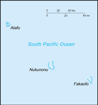
The unusual spatial pattern of the islands of the Pacific is one that many EarthView visitors find amazing. Fiji is close to the International Dateline, just off the top of EarthView's zipper. Hundreds of other islands are found throughout the Pacific -- far more than in the other oceans -- often tiny dots that are separated by huge distances, and arranged in interesting ways. Tokelau is a series of three rings, each a few miles across, with people able to inhabit only the outer edges of each. The rings are spaced evenly over 100 miles, but with a total land area of only 5 square miles! At 1,500 people, the population of the country is less than half the size of the student body at the public high school in Brockton, Massachusetts!


CIA map from thePerry-CastaƱeda Library Map Collection
at the University of Texas

The vast distances between small population centers leads to interesting results; when they were brought to Fiji, the boys were visited by relatives living there. This was not at all surprising, even though they were in a small place 600 miles from home! Today's news (which was available yesterday because of that dateline phenomenon) reported that the boys had returned home, meaning that they had flown to American Samoa, and would only have to wait two more weeks for a boat to carry them to Tokelau.

Learn more about the fascinating geography of this region from Maps of the South Pacific, a travel web site that provides an interactive map of the region as a whole and individual maps of each country. The site also explains the distinctions among Polynesia, Micronesia, and Melanesia. (It does not cover Macronesia, which is nearly antipodean, in the North Atlantic.

Earlier this year, the EarthView team followed the progress of Katie Spotz, whose Row for Water project took her across the Atlantic Ocean. She was at sea for 70 days, in a well-stocked boat and plenty of communication equipment. From her voyage we learned some of the risks involved in small-craft travel on the high seas.

Both for Katie's planned voyage and for the boys' unplanned voyage, fresh water was, ironically, a key consideration. Katie had a water filtration kit. The boys used a tarp to gather rain and mist at night. In their case, this was starting to be inadequate and they had begun to drink seawater, a dehydrating practice that would likely have proven fatal had they been at sea a few more days.

See BBC video about the story.

Thursday, December 2, 2010

Kennedy Middle School, Woburn -- Dec 3

N 42 ° 29' 34" W 71 ° 08' 46"
Learn more about Lat/Long (including how to look them up by address)


EarthView is making its first appearance in Woburn, at the Kennedy Middle School.

Our visit on December 3 coincides with the anniversaries of several geographically-significant events.

1984: A toxic cloud at the Union Carbide plant in Bhopal, India killed thousands of residents in their sleep, drawing attention to industrial safety in developing countries
1979: Iran accepted its constitution, weeks after U.S. hostages were taken
1975: Lao People's Democratic Republic proclaimed, as the government falls to communist forces
1967: First human heart transplant: Dr. Christian Barnard in South Africa
1833: First coeducational college opens: Oberlin, Ohio

Because of the Kennedy School's proximity to the now famous site of Wells G&H, we will be speaking with the older students about the role of medical geography in addressing toxic waste contamination and its affects on public health.