Visit the EarthView web site to meet the team and learn about the project.
Showing posts sorted by relevance for query tokelau. Sort by date Show all posts

Friday, December 3, 2010

A Vast Ocean, Avast!

On October 5, three boys, aged 14 and 15, set out to visit a girl they had just met at a rugby game. They were on the island of Atafu, the northernmost of three atolls in Tokelau. She had returned to her home on the southernmost island, 100 miles away. They set off in a 12-foot-boat (which could fit inside EarthView) with a few coconuts, and did not realize they were lost at sea until two weeks later. By then, a search team from New Zealand had tried -- and failed -- to find them.

A week after that, they caught a sea bird, which would be their only food source until being rescued on November 24, about 600 miles from home. They wHere taken to a hospital in Fiji, where they were found to be in remarkably good health.

They survived long after funerals had been held for them, and were at sea longer than has been documented for any other unsupported humans.

The unusual spatial pattern of the islands of the Pacific is one that many EarthView visitors find amazing. Fiji is close to the International Dateline, just off the top of EarthView's zipper. Hundreds of other islands are found throughout the Pacific -- far more than in the other oceans -- often tiny dots that are separated by huge distances, and arranged in interesting ways. Tokelau is a series of three rings, each a few miles across, with people able to inhabit only the outer edges of each. The rings are spaced evenly over 100 miles, but with a total land area of only 5 square miles! At 1,500 people, the population of the country is less than half the size of the student body at the public high school in Brockton, Massachusetts!
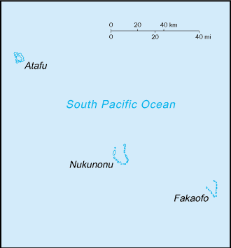

CIA map from thePerry-CastaƱeda Library Map Collection
at the University of Texas

The vast distances between small population centers leads to interesting results; when they were brought to Fiji, the boys were visited by relatives living there. This was not at all surprising, even though they were in a small place 600 miles from home! Today's news (which was available yesterday because of that dateline phenomenon) reported that the boys had returned home, meaning that they had flown to American Samoa, and would only have to wait two more weeks for a boat to carry them to Tokelau.

Learn more about the fascinating geography of this region from Maps of the South Pacific, a travel web site that provides an interactive map of the region as a whole and individual maps of each country. The site also explains the distinctions among Polynesia, Micronesia, and Melanesia. (It does not cover Macronesia, which is nearly antipodean, in the North Atlantic.

Earlier this year, the EarthView team followed the progress of Katie Spotz, whose Row for Water project took her across the Atlantic Ocean. She was at sea for 70 days, in a well-stocked boat and plenty of communication equipment. From her voyage we learned some of the risks involved in small-craft travel on the high seas.

Both for Katie's planned voyage and for the boys' unplanned voyage, fresh water was, ironically, a key consideration. Katie had a water filtration kit. The boys used a tarp to gather rain and mist at night. In their case, this was starting to be inadequate and they had begun to drink seawater, a dehydrating practice that would likely have proven fatal had they been at sea a few more days.

See BBC video about the story.

Monday, December 13, 2010

Survivor Islands

In addition to the EarthView blog, I also write for Wiley GeoDiscoveries, a blog hosted a major publisher of geography text books. For the past couple of weeks, we have been using EarthView to show the location of Tokelau and to discuss the recent rescue of three teenagers from that Pacific island nation that were lost at sea, and I published maps and other information on the EarthView blog.

Then I noticed that the story of the rescue occurred just before another interesting story about survival on Pacific Islands. This was the effort of people from small islands throughout the world to get people at the U.N. Climate Conference to consider what will happen to them and their countries as sea level rises. My article on GeoDiscoveries is called Survivor Islands.

~~ Dr. Hayes-Bohanan

Source: AOSIS

Wednesday, July 6, 2011

Kermadec Quake

29.312°S, 176.204°W
(Note decimal degrees; see lat/long article for information about conversion. How many degrees is this from your school?)


Orange, yellow, and green are closer to surface;
blue and violet are deeper than 150km
see map page for more details and views
Thanks to our local paper, the Brockton Enterprise, for letting us know about the magnitude 7.8 earthquake that struck the very remote Kermadec Islands earlier today (although it was already "tomorrow" where the quake occurred, just a few degrees east of the International Date Line. (The Globe and Mail provides just a few more details.)


The remote outpost of New Zealand houses only a weather station (currently 67 degrees F with a light breeze) and a hostel for visiting scientists. It is almost 1,000 kilometers south of Tonga, the nearest "major" island and almost 1,200 kilometers northeast of Auckland. The earthquake is remote even from these islands, with Raoul Island, the nearest, over 100 kilometers away. (See EarthView blog posts about another remote New Zealand island, Tokelau.)


The quake occurred 44 kilometers below the surface, which leads the USGS tentatively to conclude that is is located in a normal fault within the downward-moving Pacific plate.


The map at right is among several interesting depictions of seismic activity in this remote area. It indicates that the area is seismically quite active, with thousands of mostly small events over the past twenty years. Although the depth of each event can vary according to many factors, in subduction zones of this kind, the tendency -- well-illustrated here -- is for shallow events to cluster near the fault line, with depth increasing with distance away from the advancing plate (in this case, westward as the denser Pacific Plate advances under the Australian Plate).


As with any major quake in a marine environment, tsunamis are a possibility, and in this case it appears that a 2.2-foot wave was the highest generated by the event.