The EarthView team looks forward to visiting the schools listed below over the coming weeks. Details -- such as the latitude and longitude of each school -- will be included in blog postings to come.
September 18: Henry Whittemore Elementary, Waltham
September 25: Driscoll School, Brookline
October 2: Plouffe Academy, Brockton
October 23: Baker School, Brockton
December 4: James M. Quinn School, Dartmouth
Some dates are likely to be added as we continue to work out schedules with schools that have expressed interest. To bring EarthView to your school, please look at the program requirements on the EarthView web site and use the contact information provided there.

Visit the EarthView web site to meet the team and learn about the project.
Showing posts sorted by relevance for query Brockton. Sort by date Show all posts
Showing posts sorted by relevance for query Brockton. Sort by date Show all posts
Saturday, September 12, 2009


Saturday, September 26, 2009
October 2: Plouffe Academy, Brockton
42° 04' 48" N
71° 00' 40" W
Source: Steve Morse
We look forward to visiting Plouffe Academy in Brockton on October 2. EarthView Team member Dr. Hayes-Bohanan fondly remembers meeting Plouffe students (who are now adults) the first time he participated in BSC's Turning Leaves program.
Plouffe teachers and students are invited to use the "comment" link below to post questions for the EarthView Team.
Our October 2 visit is on the anniversary of several historic events and birthdays with geography connections.
EVENTS
1608 Prototype of modern reflecting telescope completed by Jan Lippershey
1836 Darwin returns to England aboard HMS Beagle (after 5 years)
1870 Italy annexes Rome and Papal States; Rome made Italian capital
1889 1st Pan American conference (Washington D.C.)
1895 1st cartoon comic strip is printed in a newspaper
1932 Washington Redskins (as Boston Braves) play 1st NFL game, lose 14-0
1949 U.S.S.R. recognizes People's Republic of China
1950 1st strip of Charlie Brown, "Li'l Folks," later "Peanuts" in 9 papers
1956 1st atomic power clock exhibited-NYC
1957 New volcano appears at western end of Faial Island, Azores
(See photo & story or find the volcano on this satellite image.)
1958 Guinea (French Guinea) gains independence from France
1967 Thurgood Marshall sworn in as 1st black Supreme Court Justice
1968 Republic Guinea forms
1971 Homing pigeon averages 133 KPH (record) in 1100-km Australian race
BIRTHDATES:
1869 Mahatma Karamchand Ghandi, Porbandar Kathiawad India, pacifist
1800 Nat Turner, Virginia, leader of major slave rebellion, 1831
71° 00' 40" W
Source: Steve Morse
We look forward to visiting Plouffe Academy in Brockton on October 2. EarthView Team member Dr. Hayes-Bohanan fondly remembers meeting Plouffe students (who are now adults) the first time he participated in BSC's Turning Leaves program.
Plouffe teachers and students are invited to use the "comment" link below to post questions for the EarthView Team.
Our October 2 visit is on the anniversary of several historic events and birthdays with geography connections.
EVENTS
1608 Prototype of modern reflecting telescope completed by Jan Lippershey
1836 Darwin returns to England aboard HMS Beagle (after 5 years)
1870 Italy annexes Rome and Papal States; Rome made Italian capital
1889 1st Pan American conference (Washington D.C.)
1895 1st cartoon comic strip is printed in a newspaper
1932 Washington Redskins (as Boston Braves) play 1st NFL game, lose 14-0
1949 U.S.S.R. recognizes People's Republic of China
1950 1st strip of Charlie Brown, "Li'l Folks," later "Peanuts" in 9 papers
1956 1st atomic power clock exhibited-NYC
1957 New volcano appears at western end of Faial Island, Azores
(See photo & story or find the volcano on this satellite image.)
1958 Guinea (French Guinea) gains independence from France
1967 Thurgood Marshall sworn in as 1st black Supreme Court Justice
1968 Republic Guinea forms
1971 Homing pigeon averages 133 KPH (record) in 1100-km Australian race
BIRTHDATES:
1869 Mahatma Karamchand Ghandi, Porbandar Kathiawad India, pacifist
1800 Nat Turner, Virginia, leader of major slave rebellion, 1831
Sunday, May 3, 2009
Edgar B. Davis School, Brockton (May 8 & 15)
N 42 ° 3' 14.5"
W 70 ° 59' 58.4"
(Source: geocoder.us)
The EarthView team will be visiting the Davis School in Brockton on both May 8 and May 15. We are making two visits because this is a combined elementary and middle school that hosts many of our education students, particularly our international students pursuing education careers.
The team is especially looking forward to this visit to a school with which Bridgewater State College has many strong connections.
We anticipate a lot of good questions during our visit. Davis students can use the "comments" link below to send us questions about geography before or after our visits!
W 70 ° 59' 58.4"
(Source: geocoder.us)
The EarthView team will be visiting the Davis School in Brockton on both May 8 and May 15. We are making two visits because this is a combined elementary and middle school that hosts many of our education students, particularly our international students pursuing education careers.
The team is especially looking forward to this visit to a school with which Bridgewater State College has many strong connections.
We anticipate a lot of good questions during our visit. Davis students can use the "comments" link below to send us questions about geography before or after our visits!
Monday, October 19, 2009
Oct. 23: Baker School, Brockton
See the Math? Baker School is at
42° 5' 49 N
70° 59' 24 W
Find the latitude and longitude of other places on your globe, in your atlas, or at Steve Morse. Then do some math!
On October 23, we visited the Baker School Elementary in Brockton, Massachusetts. Teachers and students are invited to use the "comment" link below to post questions for the EarthView Team. We are especially glad to be visiting this GREEN building, which is similar to the new GREEN science building where EarthView will be kept at Bridgewater State College.
We are also delighted that geography professors from Brazil joined us for part of our visit at Baker School.
Dr. Hayes-Bohanan told some classes about the "wedding of the waters" in Manaus, Brazil. Explore the area on Google Maps to see where Manaus is, relative to the rest of the continent. This is a false-color image, typical of many satellite images. Tan is shown as blue and urban areas as pink. Geographers learn how to use satellite data to get information about places that is more detailed than what we see in photographs; false-color images are one example.
See the Rio Negro entering from the WNW and the Rio Solimões entering from the West and WSW. As they continue past Manaus, the tea-like water of the Rio Negro remains along the left bank (north side) of the Amazon -- which is officially formed at this confluence -- for many miles. Use the scale on Google Maps to figure out how far. Visit Dr. Hayes-boh's Rondonia Web for stories about his time in the Amazon.
View Larger Map
Our visit on this day also coincides with a great number of geographically significant anniversaries and birthdays, including:
1989 Hungary proclaims itself a republic and declares communist rule ended
1978 China and Japan formally end 4 decades of dissension
1977 Panamanians vote 2:1 to approve new Canal treaties
1975 Battle between Cuba and South Africa troops in Angol
1954 Britain, England, France and U.S.S.R. agree to end occupation of Germany
1954 West Germany joins NATO
1953 France grants sovereignty to Laos
1956 Revolt against Stalinist policies begins in Hungary
787 Byzantine empress Irene recovers Iconclastic cult at Nicaea
BIRTHDATES:
1922 Stuart Sloan, war hero/test pilot
1905 Felix Bloch, Swiss/U.S. nuclear physicist, Nobel 1952
1868 Rama V, [Chulalongkorn], leader of Thailand, -1910
42° 5' 49 N
70° 59' 24 W
Find the latitude and longitude of other places on your globe, in your atlas, or at Steve Morse. Then do some math!
On October 23, we visited the Baker School Elementary in Brockton, Massachusetts. Teachers and students are invited to use the "comment" link below to post questions for the EarthView Team. We are especially glad to be visiting this GREEN building, which is similar to the new GREEN science building where EarthView will be kept at Bridgewater State College.
We are also delighted that geography professors from Brazil joined us for part of our visit at Baker School.
Dr. Hayes-Bohanan told some classes about the "wedding of the waters" in Manaus, Brazil. Explore the area on Google Maps to see where Manaus is, relative to the rest of the continent. This is a false-color image, typical of many satellite images. Tan is shown as blue and urban areas as pink. Geographers learn how to use satellite data to get information about places that is more detailed than what we see in photographs; false-color images are one example.
See the Rio Negro entering from the WNW and the Rio Solimões entering from the West and WSW. As they continue past Manaus, the tea-like water of the Rio Negro remains along the left bank (north side) of the Amazon -- which is officially formed at this confluence -- for many miles. Use the scale on Google Maps to figure out how far. Visit Dr. Hayes-boh's Rondonia Web for stories about his time in the Amazon.
View Larger Map
Our visit on this day also coincides with a great number of geographically significant anniversaries and birthdays, including:
1989 Hungary proclaims itself a republic and declares communist rule ended
1978 China and Japan formally end 4 decades of dissension
1977 Panamanians vote 2:1 to approve new Canal treaties
1975 Battle between Cuba and South Africa troops in Angol
1954 Britain, England, France and U.S.S.R. agree to end occupation of Germany
1954 West Germany joins NATO
1953 France grants sovereignty to Laos
1956 Revolt against Stalinist policies begins in Hungary
787 Byzantine empress Irene recovers Iconclastic cult at Nicaea
BIRTHDATES:
1922 Stuart Sloan, war hero/test pilot
1905 Felix Bloch, Swiss/U.S. nuclear physicist, Nobel 1952
1868 Rama V, [Chulalongkorn], leader of Thailand, -1910
Friday, December 3, 2010
A Vast Ocean, Avast!

A week after that, they caught a sea bird, which would be their only food source until being rescued on November 24, about 600 miles from home. They wHere taken to a hospital in Fiji, where they were found to be in remarkably good health.
They survived long after funerals had been held for them, and were at sea longer than has been documented for any other unsupported humans.
The unusual spatial pattern of the islands of the Pacific is one that many EarthView visitors find amazing. Fiji is close to the International Dateline, just off the top of EarthView's zipper. Hundreds of other islands are found throughout the Pacific -- far more than in the other oceans -- often tiny dots that are separated by huge distances, and arranged in interesting ways. Tokelau is a series of three rings, each a few miles across, with people able to inhabit only the outer edges of each. The rings are spaced evenly over 100 miles, but with a total land area of only 5 square miles! At 1,500 people, the population of the country is less than half the size of the student body at the public high school in Brockton, Massachusetts!
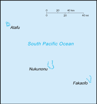 |
CIA map from thePerry-Castañeda Library Map Collection |
Learn more about the fascinating geography of this region from Maps of the South Pacific, a travel web site that provides an interactive map of the region as a whole and individual maps of each country. The site also explains the distinctions among Polynesia, Micronesia, and Melanesia. (It does not cover Macronesia, which is nearly antipodean, in the North Atlantic.
Earlier this year, the EarthView team followed the progress of Katie Spotz, whose Row for Water project took her across the Atlantic Ocean. She was at sea for 70 days, in a well-stocked boat and plenty of communication equipment. From her voyage we learned some of the risks involved in small-craft travel on the high seas.
Both for Katie's planned voyage and for the boys' unplanned voyage, fresh water was, ironically, a key consideration. Katie had a water filtration kit. The boys used a tarp to gather rain and mist at night. In their case, this was starting to be inadequate and they had begun to drink seawater, a dehydrating practice that would likely have proven fatal had they been at sea a few more days.
See BBC video about the story.
Tuesday, June 9, 2009
Coverage of EarthView visit to Davis
The May 8 & 15 visit to Davis School has led to this very nice article on the Brockton Public Schools web site. The superintendent of schools and the president of the college were both able to join students that day, and made some interesting comments about geography education.
Thursday, November 11, 2010
Trinity Catholic Academy, Brockton -- Nov 12
N 42 ° 04' 51.2"
W 71 ° 00' 23.0"
Learn more about Lat/Long (including how to look them up by address)
Here is a challenge: This school is close to the only land-based degree confluence in Massachusetts. How far is it from that point in degrees, minutes and seconds? How far is it in miles or kilometers?
 The EarthView team is looking forward to its return to Trinity Catholic Academy, which we last visited in May, 2009. We have literally seen thousands of students since then, but we look forward to returning to Trinity, where our own Ms. Joyce is one of the teachers. We know her students will be ready with great geography questions for the team.
W 71 ° 00' 23.0"
Learn more about Lat/Long (including how to look them up by address)
Here is a challenge: This school is close to the only land-based degree confluence in Massachusetts. How far is it from that point in degrees, minutes and seconds? How far is it in miles or kilometers?
Monday, October 26, 2009
Baker School Photo
Students at Baker School in Brockton were thrilled to have EarthView as part of Make-a-Difference Day, and the EarthView Team was thrilled to take part.


Wednesday, July 6, 2011
Kermadec Quake
29.312°S, 176.204°W
(Note decimal degrees; see lat/long article for information about conversion. How many degrees is this from your school?)
Thanks to our local paper, the Brockton Enterprise, for letting us know about the magnitude 7.8 earthquake that struck the very remote Kermadec Islands earlier today (although it was already "tomorrow" where the quake occurred, just a few degrees east of the International Date Line. (The Globe and Mail provides just a few more details.)
The remote outpost of New Zealand houses only a weather station (currently 67 degrees F with a light breeze) and a hostel for visiting scientists. It is almost 1,000 kilometers south of Tonga, the nearest "major" island and almost 1,200 kilometers northeast of Auckland. The earthquake is remote even from these islands, with Raoul Island, the nearest, over 100 kilometers away. (See EarthView blog posts about another remote New Zealand island, Tokelau.)
The quake occurred 44 kilometers below the surface, which leads the USGS tentatively to conclude that is is located in a normal fault within the downward-moving Pacific plate.
The map at right is among several interesting depictions of seismic activity in this remote area. It indicates that the area is seismically quite active, with thousands of mostly small events over the past twenty years. Although the depth of each event can vary according to many factors, in subduction zones of this kind, the tendency -- well-illustrated here -- is for shallow events to cluster near the fault line, with depth increasing with distance away from the advancing plate (in this case, westward as the denser Pacific Plate advances under the Australian Plate).
As with any major quake in a marine environment, tsunamis are a possibility, and in this case it appears that a 2.2-foot wave was the highest generated by the event.
(Note decimal degrees; see lat/long article for information about conversion. How many degrees is this from your school?)
 |
| Orange, yellow, and green are closer to surface; blue and violet are deeper than 150km see map page for more details and views |
The remote outpost of New Zealand houses only a weather station (currently 67 degrees F with a light breeze) and a hostel for visiting scientists. It is almost 1,000 kilometers south of Tonga, the nearest "major" island and almost 1,200 kilometers northeast of Auckland. The earthquake is remote even from these islands, with Raoul Island, the nearest, over 100 kilometers away. (See EarthView blog posts about another remote New Zealand island, Tokelau.)
The quake occurred 44 kilometers below the surface, which leads the USGS tentatively to conclude that is is located in a normal fault within the downward-moving Pacific plate.
The map at right is among several interesting depictions of seismic activity in this remote area. It indicates that the area is seismically quite active, with thousands of mostly small events over the past twenty years. Although the depth of each event can vary according to many factors, in subduction zones of this kind, the tendency -- well-illustrated here -- is for shallow events to cluster near the fault line, with depth increasing with distance away from the advancing plate (in this case, westward as the denser Pacific Plate advances under the Australian Plate).
As with any major quake in a marine environment, tsunamis are a possibility, and in this case it appears that a 2.2-foot wave was the highest generated by the event.
Friday, May 1, 2009
Trinity Catholic Academy, Brockton
N 42 ° 4' 51.2" W 71 ° 0' 23.0"
(Source: geocoder.us)
The EarthView team enjoyed the welcoming atmosphere of Trinity Academy on May 1. Students were curious and appreciative, and the attentive teachers and staff ensured a very pleasant experience.

(Source: geocoder.us)
The EarthView team enjoyed the welcoming atmosphere of Trinity Academy on May 1. Students were curious and appreciative, and the attentive teachers and staff ensured a very pleasant experience.

It was great to meet yet another BSC Geography alumna. Ms. Yvette Joyce's class had a lot of great geography questions to ask!
Team member Dr. James promised the fifth graders a link to his web pages about his 2003 study tour in Cuba. It will be interesting to see what happens now that the U.S. government is starting -- in very small ways -- to change its approach to this very interesting country.
Thanks, Trinity students for your attention and your great questions during the EarthView visit. Post more questions here, and we will try to find some answers!
Thanks, Trinity students for your attention and your great questions during the EarthView visit. Post more questions here, and we will try to find some answers!
Subscribe to:
Posts (Atom)