Visit the EarthView web site to meet the team and learn about the project.

Thursday, September 23, 2010

Spofford Pond School, Boxford -- September 24

Spofford Pond School
42°41'46"N 
71°01'02"W
(Learn more about Lat/Long for ideas that combine math and geography learning. For example, this is the farthest north we have taken EarthView; an article in the archives for November 2009 indicates the one time we came closest to this latitude -- what college was the site of that visit?)

Most EarthView programs are in Southeastern Massachusetts, relatively close to EarthView's home base at Bridgewater State University.

As geographers, we love to travel to new places, and most of the team has spent little if any time in Boxford prior to this visit. Also, our goal is to improve geographic education throughout Massachusetts, so we are delighted to have our first North Shore school visit.

In exploring the geography of Boxford, we learned that it is facing an environmental problem that some might find surprising: the margin between forest and growing suburbs includes ideal conditions for beavers. Adorable as beavers may be, they create an unusual set of problems for suburban homeowners. The town web site includes a report on beaver encroachment and what to do about it.

The EarthView team learned some interesting news about geographic research from Spofford Pond teacher Ms. Sorensen. As reported by Discovery, computer models have provided a plausible explanation for the biblical story of the parting of the Red Sea.

Friday, September 17, 2010

East Middle School in Braintree - Sept 17


42°13'15"N 
70°59'23"W
(How far is this from South Middle School? Learn more about Lat/Long)

The EarthView team is delighted to continue the new school year with a return to Braintree. We encountered a lot of great geography students last week at South Middle School. We have provided the latitude and longitude of each school (as we do for all EarthView programs).

Here is a challenge: How far apart are the schools? They would be in the same little red dot of our laser pointer on EarthView, but there is some distance between them. It be measured in feet, miles, meters, inches, or kilometers along the road or along a straight line. It can also be measured in degrees, minutes, and seconds on the globe!

Thursday, September 9, 2010

South Middle School in Braintree -- September 10

42°11'02"N 
70°59'53"W
(Learn more about Lat/Long) 

After quite an exciting summer of special appearances (see recent blog posts below) the EarthView Team is delighted to be reunited for the start of our third school year. Close to 20,000 students and community members have seen EarthView in the past two years, and we look forward to bringing our program to thousands more this year -- each in small groups that have the special experience of seeing the earth from the inside out!

We started the year with two programs in Braintree, the first of which was at South Middle School, where Mrs. Drayer teaches geography through the Olympics! We also learned that Mrs. Drayer and EarthView team member are both proud UMBC Retrievers!


Bridgewater State University

41°59'15"N 
70°58'12"W
(Kelly Gymnasium)

After 170 years as a Normal School, Teachers' College, State College -- with a few other titles over the years as well -- the home of EarthView is now the Geography Department at Bridgewater State University, the largest institution in the new Massachusetts State University system.

Opening Day this year included a visit from Gov. Deval Patrick, a fly-over courtesy of the BSU aviation program, and of course an EarthView exhibition! We were honored that our visiting librarian-scholar from Cambodia took the time to visit EarthView; having seen the Mapparium in Boston earlier in her visit, she will return to Cambodia with two very memorable geography experiences!
BSU Library Assistant Joan Luiz, Pannasastra University Librarian Vanna Sok, and EarthView Team member James Hayes-Bohanan pose directly "south" of Cambodia on BSU Opening Day.
BSU relies on energetic, cheerful, and well-informed Orientation Leaders to welcome each class to campus. This year, the OLs were enthusiastic participants in their own special orientation to the planet! One of the OLs is actually a BSU geography major. (She is shown above, in the red shirt.)

Tuesday, July 20, 2010

Latitude/Longitude Converters

Geographers and other scientists use latitude and longitude to identify places on earth reliably and precisely. Every location on earth has a unique combination of latitude (north or south of the equator) and longitude (east or west of the Prime Meridian). Geographer Matt Rosenberg explains these concepts in more detail in his article Latitude and Longitude: Discover the Secrets of Parallels and Meridians.

Latitude and longitude are each expressed as degrees or fractions of degrees. At the equator, a whole degree can be used to locate a place to within a mile or so -- a suitable level of precision for locating a city, for example. A degree comprises 60 minutes, so that a latitude or longitude expressed in degrees and minutes is precise to roughly 100 feet, which is suitable for a lot of purposes, such as finding a house. Fractions of an arc minute are known as seconds, and again there are 60 to each minute. At the equator, coordinates expressed as degrees, minutes and seconds would be precise within a couple of feet. Fractions of a second might be used for even more precise work, such as the location of property boundaries, the corners of a building, or the location of a well. (The caveat "at the equator" is used above because the surface length of a degree of latitude changes slightly from the equator to the poles because of the oblateness of the earth's shape, and the length of a degree of longitude changes dramatically, down to zero at the poles, because of the convergence of the lines there.)

Followers of this blog may already be familiar with the latitude/longitude lookup utility created by Steve Morse, which allows users to look up addresses and find latitudes and longitudes. What is especially useful about this site is that it does not draw on just one source. It uses various mapping web sites, showing that although each site is precise to the equivalent of inches or millimeters, they are only as accurate as the datasets upon which they are based. For any given address, users may find small or large differences, depending on how large a property is, and how each database treats its proximity to nearby roads.

For various reasons, it is often useful to express latitude and longitude as decimal fractions of degrees, rather than minutes and seconds. This is particularly true if distance or area calculations are being made on the basis of the coordinates. Geographers usually prefer the conventional terms, however. Conversion from one to the other is relatively simple, but it can be tedious. For this reason, the conversion utility from the FCC is particularly helpful. It allows users to enter coordinates in either format (d-m-s or decimal) and convert easily to the other. Another interesting utility allows the distance between two points to be calculated from their respective coordinates.

Have you ever heard that if you could dig a really deep hole, you could get to China? From locations in North America, this would not be the case, even if digging such a whole were possible. Geographers can use latitude and longitude to make a simple calculation of where such a journey would end, by finding the antipode. In fact, for most locations on land, the antipode is in a body of water.

"Earth Sandwich" enthusiasts have made a fun geographic project of marking antipodes by making 8,000-mile-thick sandwiches of the earth, with a piece of toast carefully located on opposite sides of the planet at the same time. A similar hobby is the marking of degree confluence points in the geodetic grid, one of which is located very close to EarthView's home in Bridgewater, Massachusetts.

Monday, July 12, 2010

Photos from Summer of Science program

EarthView team members Dr. Domingo and Dr. Hayes-Bohanan thoroughly enjoyed our visit to the Massachusetts Maritime Academy on July 9 to be part of the Summer of Science kick-off event. (Our team also included geography alumna Monique Buckley, educator and photographer extraordinaire and winner of the Rao Scholarship.) We enjoyed the company of faculty, staff, and students from all six CONNECT campuses who are bringing very impressive Science, Technology, Engineering & Math (STEM) outreach programs to the young people of southeastern Massachusetts. It was great to see so many committed colleagues and students from public higher education contributing to the development of human capital of our region from early childhood through post-graduate education.

We also had occasion to meet some of the area children who participate in the programs, and the CONNECT leaders and other officials who advocate tirelessly for public higher education in our Commonwealth. We had time to take a few photos of our own, but we know other media were present, and we hope to provide links to additional coverage in the next few days.
As EarthView fans know, we will take our giant globe anywhere there is an audience. For this occasion, we rose to a unique challenge, and safely inflated EarthView among the model engines in a mechanical teaching bay.
We were delighted to continue our discussion of K-16 geography education with our own Dr. Dana Mohler-Faria (r), President of Bridgewater State College and with Massachusetts Secretary of Education Paul Reville (2nd from left).
We were also pleased to show EarthView to Dr. Jean MacCormack, Chancellor of the University of Massachusetts-Dartmouth and Admiral Richard Gurnon, President of Mass Maritime and host of this lovely event. 

Saturday, July 3, 2010

Dartmouth Middle students journey to center of Earth

Thanks to South Coast Today for letting the Dartmouth community know about EarthView's June 8 visit to Dartmouth Middle School.

We will be back on the South Coast on July 9 as part of the Summer of Science program at Mass Maritime. EarthView will be open to the public, along with a lot of other great exhibits, from 1 to 3 pm.

Thursday, July 1, 2010

CONNECT Summer of Science -- Friday July 9

41°44'20"N 
70°37'27"W
RADM Maurice Bresnahan, Jr. Hall
Massachusetts Maritime Academy
Buzzards Bay, Massachusetts

EarthView will be part of  the CONNECT Summer of Science program on Friday, July 9. The Event showcases Science Technology Engineering and Math (STEM) education experiences for K-12 and the importance of science education.

On Friday July 9, from 1 to 3 p.m. at the Massachusetts Maritime Academy in Buzzards Bay, students, families, educators, and science buffs of all ages are invited to experience the kick-off of this year’s Summer of Science. Enjoy some ice cream, enter to win tuition waivers and discounts, and see some of the cool science and technology programs first-hand -- including EarthView!

All are welcome. Please let CONNECT know if you are planning on coming by email to kathleen.kirby@connectsemass.org.

Thursday, June 24, 2010

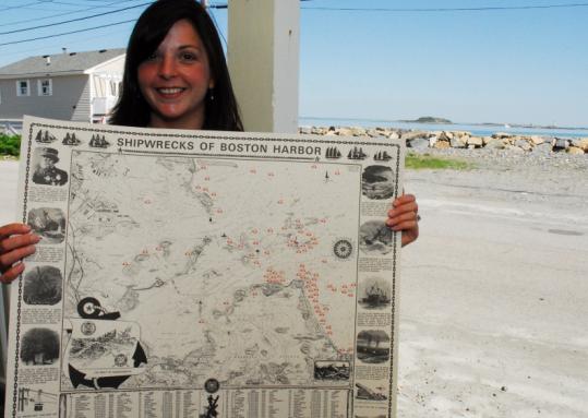
Shipwrecks of Boston Harbor

The EarthView Team salutes Victoria Stevens of the Hull Lifesaving Museum for creating a wonderful online resource for geographic education. The online map of historic Boston shipwrecks complements the museum's rich collection of artifacts and exhibits related to the heroic life-saving efforts along New England shores.


The online exhibit allows students to find information about 75 of the shipwrecks that lie beneath the waters of Boston Harbor. Students can use the map to look for patterns, such as the clustering of wrecks in certain areas or where wrecks were more common in particular time periods.

The creation of the website is described in today's Boston Globe, along with some discussion of the changes that eventually made navigation of the harbor much less hazardous.

We encourage our EarthView students to visit the museum -- online and in Hull!

Tuesday, June 22, 2010

Happy Anniversary, Quabbin

The story of the Quabbin Reservoir in central Massachusetts is rich in geographic questions. Rural towns were sacrificed to allow a city to continue growing. Ample water is piped daily from an area of surplus to an area of chronic water shortages (the amounts of rain are not that different, but the density of population certainly is). Some land was lost, while other land was protected.

On the occasion of the 64th anniversary of the filling of the Quabbin Reservoir, EarthView team member posted this remembrance on his environmental geography blog.

Friday, June 18, 2010

Beyond Earth

EarthView team member Dr. Hayes-Bohanan recently went with his family to the Smithsonian National Air & Space Museum in Washington, DC and found it full of geography lessons! This museum is free and open to the public -- part of British scientist James Smithson's immense gift to the United States (which he had never visited).

This particular part of the Smithsonian Institution is valuable for geographers in two main ways. First, aviation and aerospace technologies have greatly increased the ability of humans to explore and observe planet Earth. People now routinely travel distances in a single day that once required months, years, or even generations to traverse. Air travel makes the human connection between places much stronger than they once were -- even for people who never get on an airplane themselves. Additionally, aerial photography and satellite imagery have greatly improved our ability to map the planet.

Just as important, however, is the lessons about our own planet that can be learned from studying and exploring others. The poster shown below is one of many that makes comparisons between Earth and other planets. The online exhibition Exploring the Planets is a good place to learn more.

Wednesday, June 9, 2010

State House Visit Success

The EarthView team -- accompanied by several excellent geography teachers and students -- spent Monday, June 7 in the historic Nurses Hall of the Massachusetts State House. We met senators, representatives, staff members, BSC geography alumni, and tourists -- all of whom were excited to see the Earth in all its glory right in the People's House.

We even learned that at least one legislator has a geography degree, and many others expressed their support for our efforts to broaden geographic education in the Commonwealth and to restore licensure for geography teachers in the near future.

See more photos of the event on Flickr.