Thursday, November 11, 2010
Trinity Catholic Academy, Brockton -- Nov 12
N 42 ° 04' 51.2"
W 71 ° 00' 23.0"
Learn more about Lat/Long (including how to look them up by address)
Here is a challenge: This school is close to the only land-based degree confluence in Massachusetts. How far is it from that point in degrees, minutes and seconds? How far is it in miles or kilometers?
The EarthView team is looking forward to its return to Trinity Catholic Academy, which we last visited in May, 2009. We have literally seen thousands of students since then, but we look forward to returning to Trinity, where our own Ms. Joyce is one of the teachers. We know her students will be ready with great geography questions for the team.
W 71 ° 00' 23.0"
Learn more about Lat/Long (including how to look them up by address)
Here is a challenge: This school is close to the only land-based degree confluence in Massachusetts. How far is it from that point in degrees, minutes and seconds? How far is it in miles or kilometers?
The EarthView team is looking forward to its return to Trinity Catholic Academy, which we last visited in May, 2009. We have literally seen thousands of students since then, but we look forward to returning to Trinity, where our own Ms. Joyce is one of the teachers. We know her students will be ready with great geography questions for the team.
Saturday, November 6, 2010
Largest Countries
Although the EarthView globe does not show political boundaries, we often discuss the locations of countries, especially those with the largest populations. As of 2010, the ten most populous countries are those listed above. The U.S. Census Bureau's country rankings page allows users to find the rank of any country in any year from 1950 to 2050 (future rankings are estimates, of course).
To make direct comparisons possible, the database shows the ranking of Russia for all years, even though prior to 1991 it was not listed separately and was part of the Soviet Union's number-three ranking. Its first post-Soviet ranking was number six, but it has now fallen to number nine. Use the database to estimate when Russia will drop from the top-ten ranking in population.
Its position as the largest country by land area will not change, of course, as 11.5 percent of the earth's land is in Russia, no matter how many people live there.
To make direct comparisons possible, the database shows the ranking of Russia for all years, even though prior to 1991 it was not listed separately and was part of the Soviet Union's number-three ranking. Its first post-Soviet ranking was number six, but it has now fallen to number nine. Use the database to estimate when Russia will drop from the top-ten ranking in population.
Its position as the largest country by land area will not change, of course, as 11.5 percent of the earth's land is in Russia, no matter how many people live there.
| COUNTRY OR AREA | POPULATION 2010 |
| | 1,330,141,295 |
| | 1,173,108,018 |
| | 310,232,863 |
| | 242,968,342 |
| | 201,103,330 |
| | 184,404,791 |
| | 156,118,464 |
| | 152,217,341 |
| | 139,390,205 |
| | 126,804,433 |
| This map was created by the US CIA but is hosted on the web site of the Embassy of Russia to the UK |
Armenian Sisters' Academy, Lexington -- November 15
42° 26' 16" N
71° 13' 06" W
Learn more about Lat/Long
Members of the EarthView team and other Bridgewater State University Geographers are looking forward to a visit to the Armenian Sisters' Academy in Lexington on November 15. Our visit is on the anniversary of several interesting geographic events, which are listed at the end of this post.
The school was founded by Sister Alphonsa Bedrosian, beginning as a much smaller institution in Watertown and expanded on its current campus in 1982. The school serves both Armenian and non-Armenian children through middle school, with an emphasis on Armenian history and culture. The Armenian Sisters of the Immaculate Conception operate the academy in Lexington as well as two others in the United States -- in Philadelphia and Los Angeles -- as well as others throughout the world.
View Larger Map
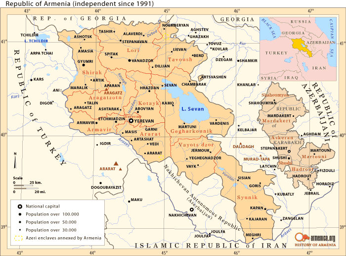
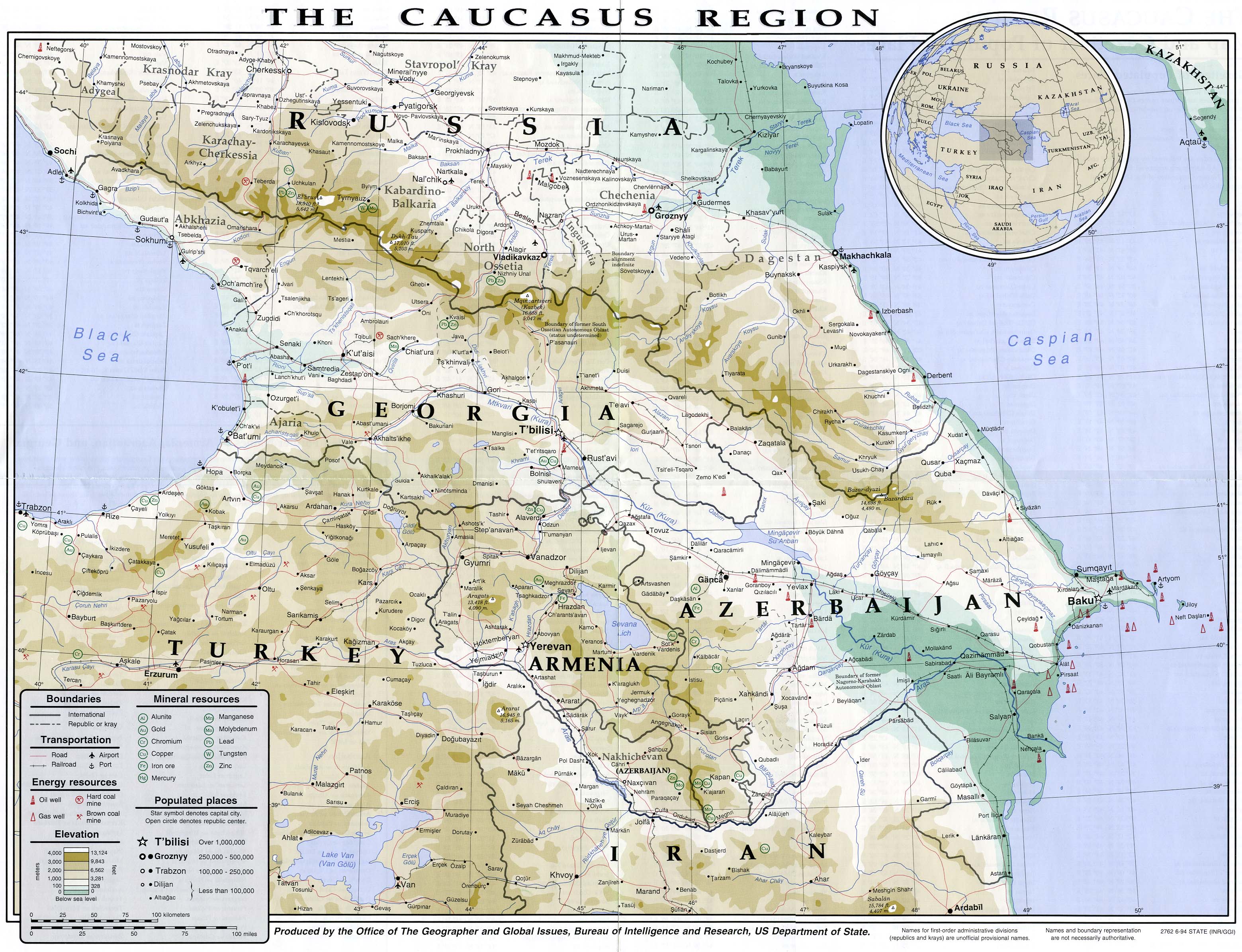
Armenia is a small country located in the center of the Caucasus region of southeastern Europe. Many Armenian Americans live in the greater Boston area. See the Armenia maps at the Perry-CastaƱeda Library Map Collection for more maps Armenia and the surrounding region, reflecting boundaries recognized by the United States. Also see the fascinating and complete collection of maps at Armenica.org. We are using maps from both collections in a special slide show for students at the Academy.
The EarthView visit takes place on the anniversary of several significant geographic milestones.
November 15, 1990
President Bush signed the Clean Air Act Amendments of 1990, making the 1970 law stronger
November 15, 1806
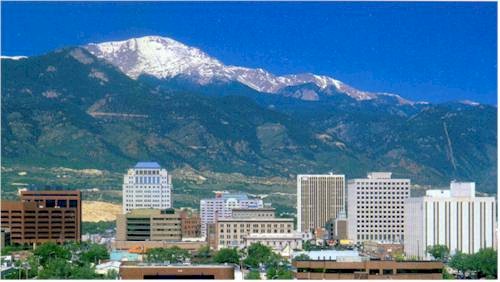
Explorer Zebulon Pike sighted Pikes Peak, in Colorado, which was later named in his honor.
November 15, 1763
Almost a century before the U.S. Civil War, Charles Mason and Jeremiah Dixon began surveying Mason-Dixon Line between Pennsylvania and Maryland.
71° 13' 06" W
Learn more about Lat/Long
Members of the EarthView team and other Bridgewater State University Geographers are looking forward to a visit to the Armenian Sisters' Academy in Lexington on November 15. Our visit is on the anniversary of several interesting geographic events, which are listed at the end of this post.
The school was founded by Sister Alphonsa Bedrosian, beginning as a much smaller institution in Watertown and expanded on its current campus in 1982. The school serves both Armenian and non-Armenian children through middle school, with an emphasis on Armenian history and culture. The Armenian Sisters of the Immaculate Conception operate the academy in Lexington as well as two others in the United States -- in Philadelphia and Los Angeles -- as well as others throughout the world.
View Larger Map
Armenia is a small country located in the center of the Caucasus region of southeastern Europe. Many Armenian Americans live in the greater Boston area. See the Armenia maps at the Perry-CastaƱeda Library Map Collection for more maps Armenia and the surrounding region, reflecting boundaries recognized by the United States. Also see the fascinating and complete collection of maps at Armenica.org. We are using maps from both collections in a special slide show for students at the Academy.
The EarthView visit takes place on the anniversary of several significant geographic milestones.
November 15, 1990
President Bush signed the Clean Air Act Amendments of 1990, making the 1970 law stronger
November 15, 1806
Explorer Zebulon Pike sighted Pikes Peak, in Colorado, which was later named in his honor.
| Image: Pikes Peak Radio & Electronics Museum |
November 15, 1763
Almost a century before the U.S. Civil War, Charles Mason and Jeremiah Dixon began surveying Mason-Dixon Line between Pennsylvania and Maryland.
Monday, November 1, 2010
North Reading Middle School
42° 34' 36" N
71° 05' 17" W
Learn more about Lat/Long
North Reading is the home of Jon Favreau, who graduated from North Reading High School less than a decade ago and is already the chief speech-writer for President Barack Obama.
The EarthView team is visiting North Reading Middle School on November 5, on the 75th anniversary of the board game Monopoly. What is geographic about this game? (Hint: In 1972, fans of the game actually prevented a U.S. city from changing the names of two of its streets!)
November 5 is also the date on which -- in 1492 -- Christopher Columbus first learned about corn, the cultivation of which had by then already spread from central Mexico to the island of Cuba. What is the importance of corn today?
71° 05' 17" W
Learn more about Lat/Long
North Reading is the home of Jon Favreau, who graduated from North Reading High School less than a decade ago and is already the chief speech-writer for President Barack Obama.
The EarthView team is visiting North Reading Middle School on November 5, on the 75th anniversary of the board game Monopoly. What is geographic about this game? (Hint: In 1972, fans of the game actually prevented a U.S. city from changing the names of two of its streets!)
November 5 is also the date on which -- in 1492 -- Christopher Columbus first learned about corn, the cultivation of which had by then already spread from central Mexico to the island of Cuba. What is the importance of corn today?
Friday, October 29, 2010
Coincidence in the Ring of Fire?
EarthView students know that the island nation of Indonesia -- the world's fourth-most populous country -- is located on the Pacific Ring of Fire.
The eruption and the earthquake that triggered the tsunami this week occurred 800 miles apart, affecting two separate islands -- Java and Sumatra. They may be related, as have similarly distant events in the past, such as an Alaska earthquake and geyser activity in Yellowstone, Wyoming. Indonesia is the most tectonically active place on Earth, however, so it will be some time before a connection can be proven or discounted.
Learn more about this week's tragedies and the possible connections from National Geographic magazine.
| National Geographic photo of damage from 2004 tsunami |
Friday, October 22, 2010
Gordon Mitchell School, East Bridgewater -- October 22
42° 01' 50" N
70° 56' 43" W
Learn more about Lat/Long
The EarthView team is delighted to be returning to the Gordon W. Mitchell School in neighboring East Bridgewater, Massachusetts, which the team last visited in 2009. In fact, two Mitchell students are close family friends of team member Dr. Hayes-Bohanan.
The school is located very close to a site known as Sachem Rock, where the original conveyance of land from the Wampanoag Indians to Miles Standish in 1651. This land became the town of Bridgewater in 1656, and that town was eventually divided into what we now know as seven different cities and towns. In some ways, this was the beginning of the westward expansion of what would become the United States.
During the visit, the team was accompanied by Kiado Cruz, a farmer and activist from Chiapas, Mexico, and his team from Witness for Peace. They gave a presentation on the importance of local agriculture at Bridgewater State University on October 21 as part of a New England tour of schools, churches, and civic organizations. Although Kiado, Nikky, and Susan did not have a chance to visit with Mitchell students, they did have an opportunity to see the world from the inside, and to contemplate their own important work in a global context.
70° 56' 43" W
Learn more about Lat/Long
The EarthView team is delighted to be returning to the Gordon W. Mitchell School in neighboring East Bridgewater, Massachusetts, which the team last visited in 2009. In fact, two Mitchell students are close family friends of team member Dr. Hayes-Bohanan.
The school is located very close to a site known as Sachem Rock, where the original conveyance of land from the Wampanoag Indians to Miles Standish in 1651. This land became the town of Bridgewater in 1656, and that town was eventually divided into what we now know as seven different cities and towns. In some ways, this was the beginning of the westward expansion of what would become the United States.
During the visit, the team was accompanied by Kiado Cruz, a farmer and activist from Chiapas, Mexico, and his team from Witness for Peace. They gave a presentation on the importance of local agriculture at Bridgewater State University on October 21 as part of a New England tour of schools, churches, and civic organizations. Although Kiado, Nikky, and Susan did not have a chance to visit with Mitchell students, they did have an opportunity to see the world from the inside, and to contemplate their own important work in a global context.
Monday, October 18, 2010
Drying Lakes
| Lake Chad images (1972 and 1987) as posted Waterless on the Town Square blog |
EarthView is a terrific learning tool, whether viewed from inside or out. During today's program at the Ahern Middle School, a student looking at north-central Africa from outside asked about the body of water surrounded by dry land. What she was noticing was Lake Chad, which was once the sixth-largest lake in the world but had already lost a considerable amount of its surface area by the time EarthView was painted in the 1990s. In that sense it is much like the Aral Sea, which long ago surrendered its status as the world's fourth-largest lake, and which the EarthView artist represented with a similar, broad fringe of dry land.
Both lakes are found in arid or semi-arid lands, and are shared by multiple countries -- Nigeria, Niger, Chad, and Cameroon in the first case and Kazakhstan and Uzbekistan in the latter. Moreover, in the case of the Aral Sea, lands in four additional countries contributed directly to the drainage area of the sea.
| Image from the Fire Earth blog |
Growing or shrinking lakes represent shifts in the water balance for the watersheds (also known as drainage basins) in which they are found. Lakes can shrink as a result of water use that exceeds rainfall in the basin as a whole. This in turn can affect habitat in and near the lake, the availability of irrigation or drinking water, and even the regional climate.
Both of these shrinking lakes are excellent examples of the use of satellite images to monitor lakes. The United State Geological Survey (USGS) includes both Lake Chad and the Aral Sea in its EarthShot series, which documents many other examples of the uses of remote sensing. The Visualizing Earth project at UC-San Diego has a similar Aral Sea page that -- like the EarthShots pages -- allows users to move between satellite and ground-level images.
For decades to come, Lake Chad and the Aral Sea will remain reminders of how seriously humans can damage the natural environments on which we depend. Despite the bad news, some positive steps are being taken: international bodies are working together to protect the wetlands of Lake Chad and a new dam is helping to increase the flow of water to the Aral Sea. People in many countries have much more to do, however, if these lakes are to be fully restored!
Thursday, October 14, 2010
Ahern Middle School - Foxborough - October 15
42° 4' 27" N
71° 14' 18" W
Learn more about Lat/Long
The John J. Ahern Middle School in Foxborough is hosting the EarthView team for the third time in the program's three years. A lot has happened with EarthView and with the Geography Department that runs the program since the first visit in 2008.
For example, the department is no longer part of Bridgewater State College -- it is now part of Bridgewater State UNIVERSITY, a teaching university that will continue to serve the region. Second, the department -- formerly in the School of Arts & Sciences -- is now part of the university's new School of Science & Mathematics. Geography is both a social and a physical science, connected to the other so-called STEM disciplines.
The EarthView team is particularly interested to learn that Ahern will soon have a family math night. We will be sharing ideas with Ahern teachers about ways to include geographic fun in that event!
To learn more about what EarthView has achieved over the past three years and what still lies ahead, the team invites you to scroll through the blog -- which now has close to 100 articles about school visits, geographic education, and some fascinating stories of our planet!
71° 14' 18" W
Learn more about Lat/Long
The John J. Ahern Middle School in Foxborough is hosting the EarthView team for the third time in the program's three years. A lot has happened with EarthView and with the Geography Department that runs the program since the first visit in 2008.
For example, the department is no longer part of Bridgewater State College -- it is now part of Bridgewater State UNIVERSITY, a teaching university that will continue to serve the region. Second, the department -- formerly in the School of Arts & Sciences -- is now part of the university's new School of Science & Mathematics. Geography is both a social and a physical science, connected to the other so-called STEM disciplines.
The EarthView team is particularly interested to learn that Ahern will soon have a family math night. We will be sharing ideas with Ahern teachers about ways to include geographic fun in that event!
To learn more about what EarthView has achieved over the past three years and what still lies ahead, the team invites you to scroll through the blog -- which now has close to 100 articles about school visits, geographic education, and some fascinating stories of our planet!
Tuesday, October 5, 2010
Circle of Illumination
![]() |
| WORLD SUNLIGHT MAP |
In the hallway outside the Geography Department office at Bridgewater State University is a fascinating device known as Geochron. Manufactured decades ago, it is a combination map and clock that is configured so that it always represents the areas of the earth in sunlight and darkness. At all times, exactly one half of the earth is illuminated by the sun, though cloud cover can affect how much reaches the surface and latitude can influence its intensity. The 50 percent in sunlight is known as the circle of illumination, because the boundary between sunlight and darkness forms a circle.
On the equinoxes, the circle of illumination intersects both the north and south poles, but during the rest of the year, the circle appears tilted first one way and then another, as the earth orbits the sun at a constant 23.5-degree angle. During this orbit, the apparent position of the sun changes steadily, and it appears directly overhead at only one place at a time on the planet. That location is known as the sub-solar point, and it oscillates from the Tropic of Cancer on the summer solstice to the Tropic of Capricorn on the winter solstice (as defined in the northern hemisphere -- people in the south use the opposite terminology).
On the original, mechanical Geochron, a small dot represents the single place on earth -- always in the tropics -- where the sun appears to be directly overhead. Of course, there is only one such point at any time, known as the sub-solar point because it appears to be under the sun.It moves from the Tropic of Cancer on our summer solstice to the Tropic of Cancer on our winter solstice, crossing the equator on the equinoxes.
Two digital versions of the GeoChron are readily available online. The World Sunlight Map shown above also represents current cloud cover and is available in several different projections. The NIST version from the National Institute of Standards is accompanied by the current, official time as used for U.S. Government purposes. (Be sure to adjust the time zone or display options if necessary.)
With parental permission, it is also now possible to install a miniature version of the GeoChron as a desktop gadget on your computer, allowing you to track the sun at all times.
World Daylight Clock on Your Desktop
The circle of illumination always lights half of the earth's surface, with the other half left in darkness and a thin band of twilight in between. You can check the digital version of GeoChron on the EarthView blog throughout the year to learn how the illuminated area changes through the seasons. You can also -- with parental permission -- install the World Daylight Clock (a Google Gadget) on your desktop to watch the progress of the sun minute-by-minute.
I captured the image above just a couple minutes ago, while writing this article. It shows that my home in Bridgewater is about to rotate into the circle of illumination, and indeed it is twighlight outside my window.
Thursday, September 23, 2010
Spofford Pond School, Boxford -- September 24
| Spofford Pond School |
71°01'02"W
(Learn more about Lat/Long for ideas that combine math and geography learning. For example, this is the farthest north we have taken EarthView; an article in the archives for November 2009 indicates the one time we came closest to this latitude -- what college was the site of that visit?)
Most EarthView programs are in Southeastern Massachusetts, relatively close to EarthView's home base at Bridgewater State University.
As geographers, we love to travel to new places, and most of the team has spent little if any time in Boxford prior to this visit. Also, our goal is to improve geographic education throughout Massachusetts, so we are delighted to have our first North Shore school visit.
In exploring the geography of Boxford, we learned that it is facing an environmental problem that some might find surprising: the margin between forest and growing suburbs includes ideal conditions for beavers. Adorable as beavers may be, they create an unusual set of problems for suburban homeowners. The town web site includes a report on beaver encroachment and what to do about it.
The EarthView team learned some interesting news about geographic research from Spofford Pond teacher Ms. Sorensen. As reported by Discovery, computer models have provided a plausible explanation for the biblical story of the parting of the Red Sea.
Friday, September 17, 2010
East Middle School in Braintree - Sept 17
42°13'15"N
The EarthView team is delighted to continue the new school year with a return to Braintree. We encountered a lot of great geography students last week at South Middle School. We have provided the latitude and longitude of each school (as we do for all EarthView programs).
Here is a challenge: How far apart are the schools? They would be in the same little red dot of our laser pointer on EarthView, but there is some distance between them. It be measured in feet, miles, meters, inches, or kilometers along the road or along a straight line. It can also be measured in degrees, minutes, and seconds on the globe!
Subscribe to:
Posts (Atom)